
A New Map of the World - Encyclopedia Britannica - Andrew Bell & Colin Macfarquhar- Philadelphia / Plate CCXIII - 1793
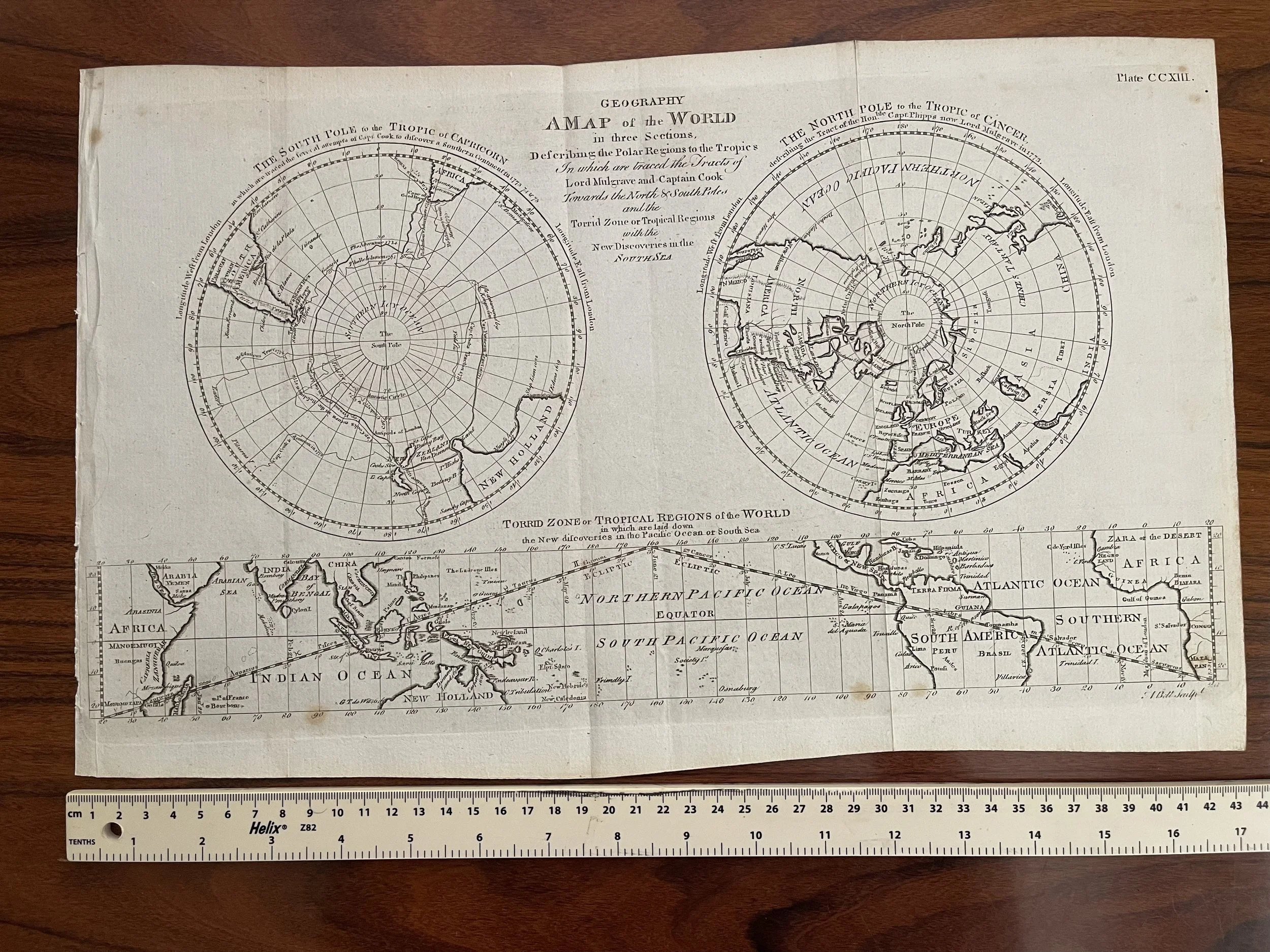
A New Map of the World in Three Sections Describing the Polar Regions to the Tropics In which are traced the Tracts of Lord Mulgrave and Captain Cook Towards the North and South Poles and the Torrid Zone or Tropical Regions with the New Discoveries in the North Sea. The map is quite rare with not many examples available.
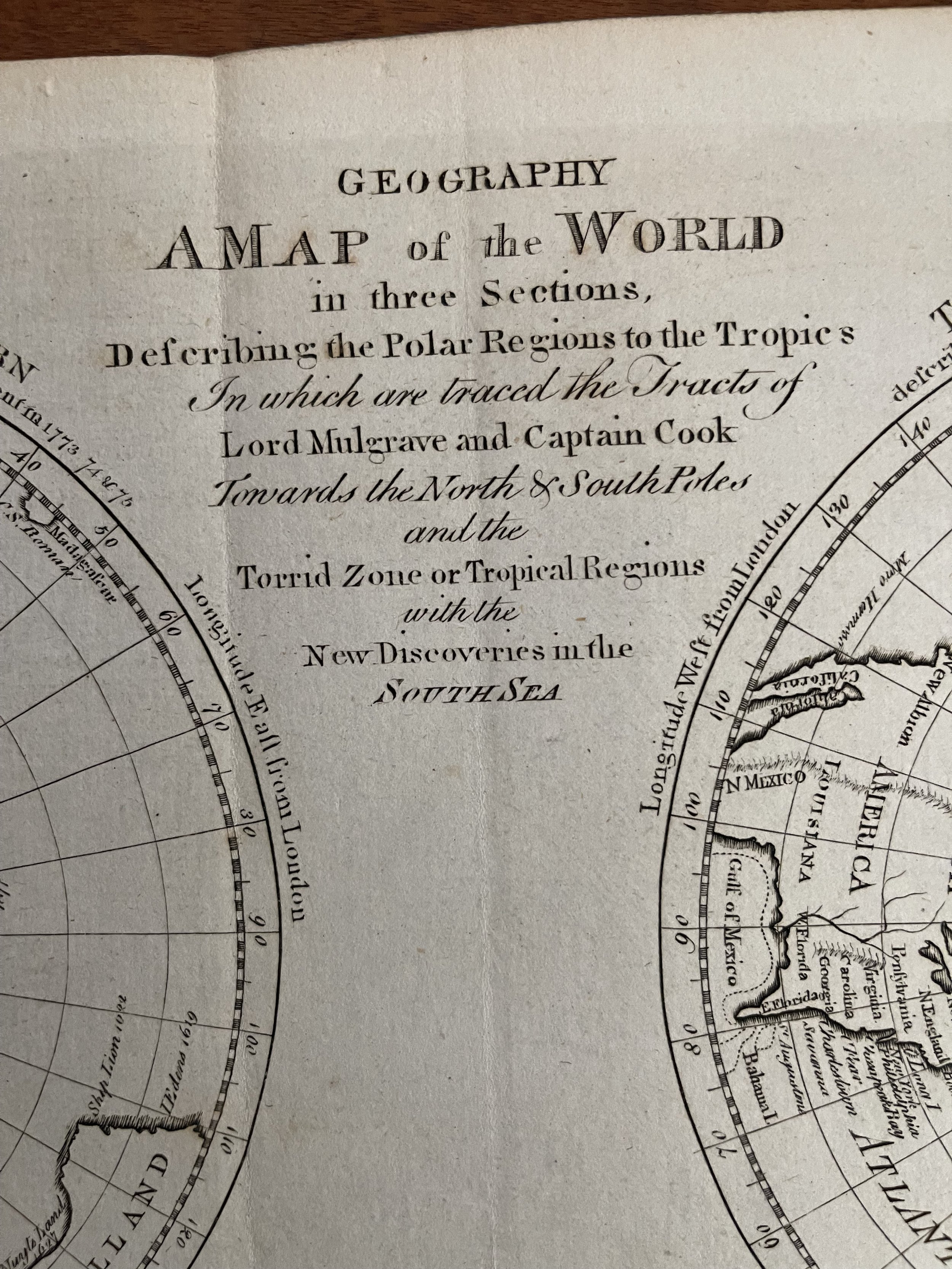
This tri-partite world map featured in the first American edition of the Encyclopedia Britannica, published by Thomas Dobson in Philadelphia from 1789 to 1798. It shows the world divided in three: the North and South Pole on Polar projections, with a cylindrical projection of the tropics at the bottom. A multi-part projection like this is rare, as is a map from the American edition.
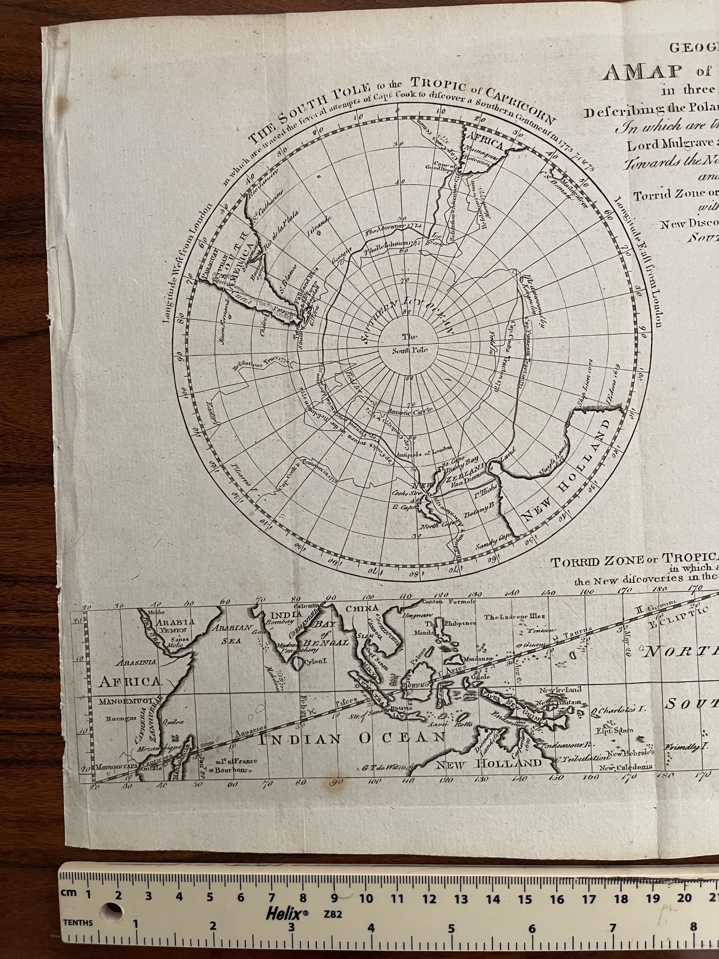
The South Pole projection is on the left, showing the region radiating around the pole to the Tropic of Capricorn. The tips of South America and Africa just peek out from the rim, while New Holland and New Zealand are also labeled. At the center of the projection, however, is nothing except for criss-crossing tracks of ships, those of the Resolution and Adventure. At the center of the ships' transits is only a "Southern Icy Ocean."
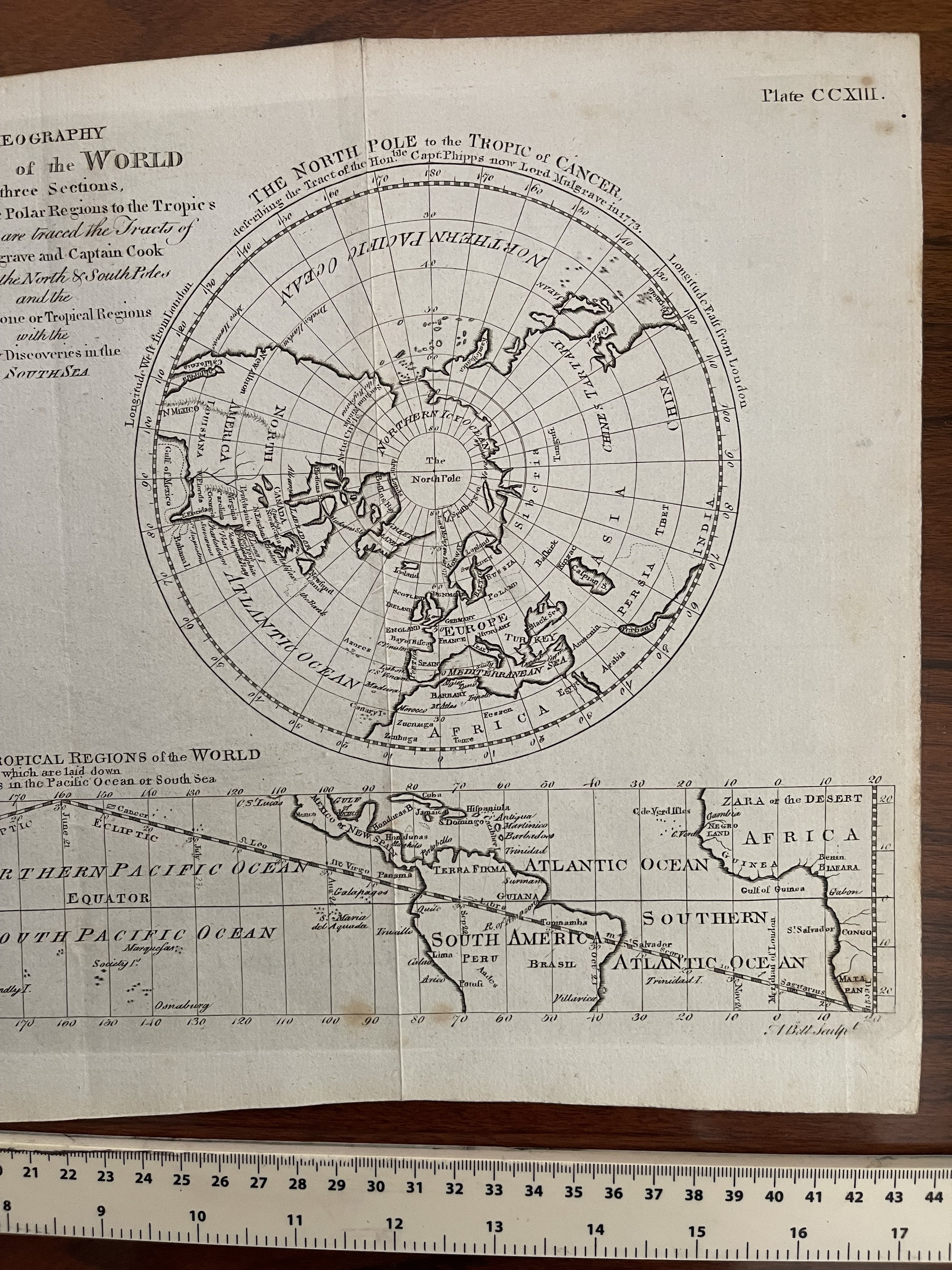
The North Pole projection is more dominated by land, with the much of North America, Europe, and Asia showing, along with North Africa. However, like the South, the pole itself is covered only with a "Northern Icy Ocean". A ship's track is also shown here, this time that of Commodore Constantine John Phipps.
Running below the circular maps is a cylindrical projection showing the latitudes missing from the polar projections, the "Torrid Zone or Tropical Regions of the World". Unusually, the Pacific Ocean is placed at the center, the better to highlight the "New discoveries in the Pacific Ocean or South Sea." The map's purpose is to show the achievements of recent exploration, thus the Pacific is dotted with islands that only recently had become familiar to readers of voyage accounts.
Encyclopedia Britannica in Britain, Ireland, and America
The map first appeared in several editions of the Encyclopedia Britannica, the oldest English-language encyclopedia still in production. The first edition was released in serial pamphlet form from 1768 to 1771; when bound it filled three volumes. This first edition's section on geography included several maps, all engraved by Andrew Bell. Bell was the engraver of all the illustrations for the original Encyclopedia, while the printing and fundraising was done by Colin Macfarquhar and the writing and research by William Smellie. All three were Scots and the Encyclopedia was published in Edinburgh for its first six editions, or until 1826.
The second edition (1777-1784) expanded to ten volumes, and the geography article was significantly lengthened. The plates also multiplied to 340, and it is in the second edition that this particular tri-part map debuted; this map is plate 213, as seen in the upper right corner. Andrew Bell is listed as the engraver in the bottom right corner of the second edition states.
The map was also in the third Edinburgh edition (18 volumes, 542 plates; 1788-1797). This edition was pirated by James Moore in Dublin, but the map in the Dublin edition has no engraver included. Additionally, the third edition was reprinted and slightly expanded (21 volumes (with 3 volume supplement), 595 plates; 1789-1798, supplement in 1803) by the American publisher Thomas Dobson, who also released the first Hebrew Bible printed in the United Sates. This particular example is special in that it comes from this first American edition, specifically from volume VII (1793).
A New Map of the World in Three Sections Describing the Polar Regions to the Tropics In which are traced the Tracts of Lord Mulgrave and Captain Cook Towards the North and South Poles and the Torrid Zone or Tropical Regions with the New Discoveries in the North Sea. The map is quite rare with not many examples available.
This tri-partite world map featured in the first American edition of the Encyclopedia Britannica, published by Thomas Dobson in Philadelphia from 1789 to 1798. It shows the world divided in three: the North and South Pole on Polar projections, with a cylindrical projection of the tropics at the bottom. A multi-part projection like this is rare, as is a map from the American edition.
The South Pole projection is on the left, showing the region radiating around the pole to the Tropic of Capricorn. The tips of South America and Africa just peek out from the rim, while New Holland and New Zealand are also labeled. At the center of the projection, however, is nothing except for criss-crossing tracks of ships, those of the Resolution and Adventure. At the center of the ships' transits is only a "Southern Icy Ocean."
The North Pole projection is more dominated by land, with the much of North America, Europe, and Asia showing, along with North Africa. However, like the South, the pole itself is covered only with a "Northern Icy Ocean". A ship's track is also shown here, this time that of Commodore Constantine John Phipps.
Running below the circular maps is a cylindrical projection showing the latitudes missing from the polar projections, the "Torrid Zone or Tropical Regions of the World". Unusually, the Pacific Ocean is placed at the center, the better to highlight the "New discoveries in the Pacific Ocean or South Sea." The map's purpose is to show the achievements of recent exploration, thus the Pacific is dotted with islands that only recently had become familiar to readers of voyage accounts.
Encyclopedia Britannica in Britain, Ireland, and America
The map first appeared in several editions of the Encyclopedia Britannica, the oldest English-language encyclopedia still in production. The first edition was released in serial pamphlet form from 1768 to 1771; when bound it filled three volumes. This first edition's section on geography included several maps, all engraved by Andrew Bell. Bell was the engraver of all the illustrations for the original Encyclopedia, while the printing and fundraising was done by Colin Macfarquhar and the writing and research by William Smellie. All three were Scots and the Encyclopedia was published in Edinburgh for its first six editions, or until 1826.
The second edition (1777-1784) expanded to ten volumes, and the geography article was significantly lengthened. The plates also multiplied to 340, and it is in the second edition that this particular tri-part map debuted; this map is plate 213, as seen in the upper right corner. Andrew Bell is listed as the engraver in the bottom right corner of the second edition states.
The map was also in the third Edinburgh edition (18 volumes, 542 plates; 1788-1797). This edition was pirated by James Moore in Dublin, but the map in the Dublin edition has no engraver included. Additionally, the third edition was reprinted and slightly expanded (21 volumes (with 3 volume supplement), 595 plates; 1789-1798, supplement in 1803) by the American publisher Thomas Dobson, who also released the first Hebrew Bible printed in the United Sates. This particular example is special in that it comes from this first American edition, specifically from volume VII (1793).
Code : A76
Cartographer : Cartographer / Engraver / Publisher: Andrew Bell & Colin Macfarquhar
Date : 1786 Approx
Size : Sheet size: 17 x 9.5 inches
Availability : Available
Type - Genuine Antique
Grading - A-