Antarctic Regions and US Panama Canal route on reverso - C. S. Hammond & Company - 1920 (Two Maps Available)
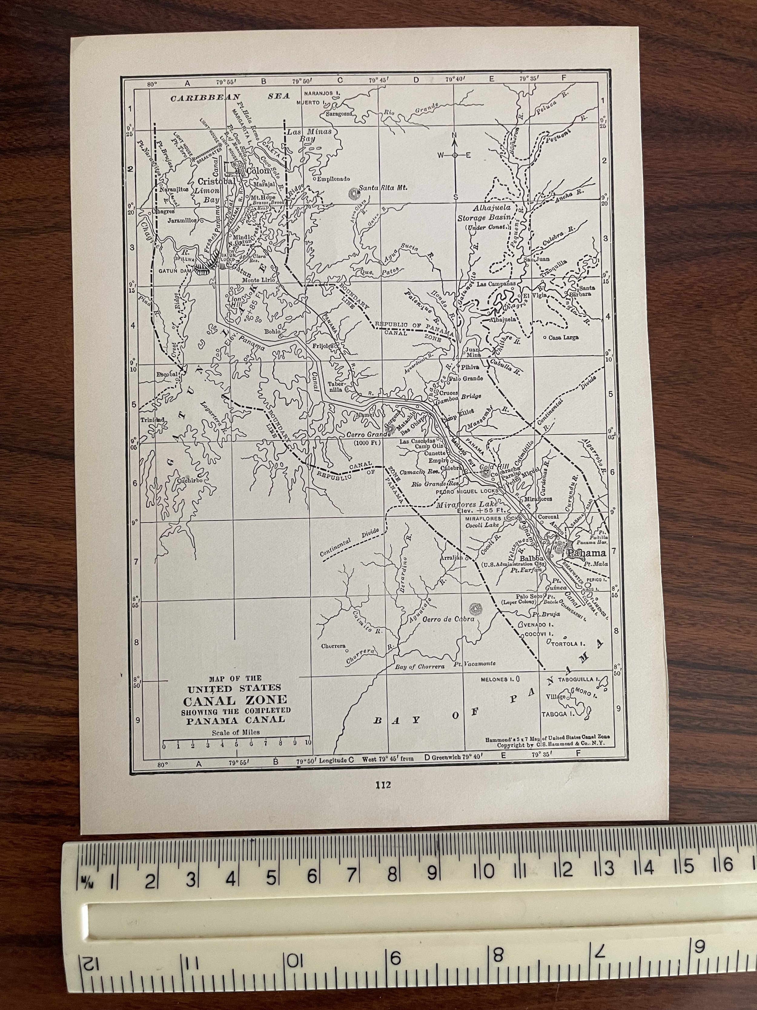
A map of the South Polar Region from 1920 showing the routes of several Antarctic explorations. On the reverso, There is a map showing the United States completed Panama Canal Zone
The New Reference Atlas of the World - A New Series of Physical, Political and Historical Maps compiled from Government Surveys and exhibiting the Latest Results of Geographical Research (New York, NY: C. S. Hammond & Company, 1920)
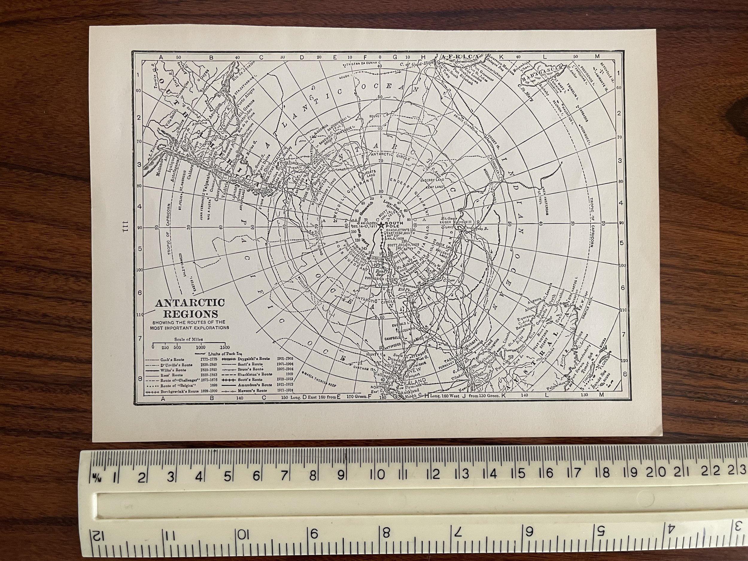
The map shows the route used and date Amundsen first reached the South Pole (December 14–17, 1911), and routes of Cook (1772–1775), D'Urville (1838–1840), Wilke (1839–1840), Ross (1839–1843), Borchgrevink (1898–1900), Drygalaki (1901–1903), Scott (1901–1904), Bruce (1902–1904), Shackleton (1909), Scott (1910–1913), Amundsen (1911–1912), and Mawson (1911–1914). This map shows Antarctica divided into the Wendell Quadrant, Enderby Quadrant, Victoria Quadrant, and Ross Quadrant.Place Names: Antarctic Region, Davis (Australia),
Dumont dUrville (France),
Maitri (India),
Mcmurdo (U.S.),
Mostok (Russia),
Neumayer (Germany),
Orcadas (Argentina),
Sanae IV (South Africa),
Syowa (Japan),
Zhong Shan (ChinaISO Topic Categories: oceans, location, inland Waters.C.S. Hammond & co. 1900 - current
New York, Brooklyn & Boston founded by Caleb still son Hammond in 1900, and formally incorporated in 1901, the company has been known over much of its history as c.s. Hammond & co. unlike most globe manufacturing in the United States, which was cantered in Chicago at the beginning of the 20th century, c.s. Hammond began work in New York city.
Hammond is well-known for its extensive line of world, historical, school, and thematic atlases, and globes, but the company has issued a wide variety of other cartographic items, including maps and transparencies during the last 100 years. it has also printed numerous other works, primarily for the educational market. in addition to its own imprints, Hammond’s cartographic output has been included in the encyclopaedias, almanacs, dictionaries, bibles, and textbooks of many other publishers.
However, in addition to manufacturing their own globes, they used both W.& A.K. Johnston and Chicago gores with a Hammond label over the original cartouche. In its heyday in the early 1960s, Hammond employed 120 draftsmen, artists, and researchers at its comfortable, panelled offices an easy walk from the quaint Maplewood village centre. now the maps are reproduced by a half-dozen computer technicians at a generic office complex in Springfield (and reviewers say the quality of the maps remains high). the only person left who remembers Hammond of the old days is an elderly secretary. there is still a Hammond world atlas corp., but the company is now a wholly owned subsidiary of Langenscheidt publishing group, a German publishing behemoth whose other acquisitions include haustrum maps, American map corp., Berlitz, and the World Almanac.
A map of the South Polar Region from 1920 showing the routes of several Antarctic explorations. On the reverso, There is a map showing the United States completed Panama Canal Zone
The New Reference Atlas of the World - A New Series of Physical, Political and Historical Maps compiled from Government Surveys and exhibiting the Latest Results of Geographical Research (New York, NY: C. S. Hammond & Company, 1920)
The map shows the route used and date Amundsen first reached the South Pole (December 14–17, 1911), and routes of Cook (1772–1775), D'Urville (1838–1840), Wilke (1839–1840), Ross (1839–1843), Borchgrevink (1898–1900), Drygalaki (1901–1903), Scott (1901–1904), Bruce (1902–1904), Shackleton (1909), Scott (1910–1913), Amundsen (1911–1912), and Mawson (1911–1914). This map shows Antarctica divided into the Wendell Quadrant, Enderby Quadrant, Victoria Quadrant, and Ross Quadrant.Place Names: Antarctic Region, Davis (Australia),
Dumont dUrville (France),
Maitri (India),
Mcmurdo (U.S.),
Mostok (Russia),
Neumayer (Germany),
Orcadas (Argentina),
Sanae IV (South Africa),
Syowa (Japan),
Zhong Shan (ChinaISO Topic Categories: oceans, location, inland Waters.C.S. Hammond & co. 1900 - current
New York, Brooklyn & Boston founded by Caleb still son Hammond in 1900, and formally incorporated in 1901, the company has been known over much of its history as c.s. Hammond & co. unlike most globe manufacturing in the United States, which was cantered in Chicago at the beginning of the 20th century, c.s. Hammond began work in New York city.
Hammond is well-known for its extensive line of world, historical, school, and thematic atlases, and globes, but the company has issued a wide variety of other cartographic items, including maps and transparencies during the last 100 years. it has also printed numerous other works, primarily for the educational market. in addition to its own imprints, Hammond’s cartographic output has been included in the encyclopaedias, almanacs, dictionaries, bibles, and textbooks of many other publishers.
However, in addition to manufacturing their own globes, they used both W.& A.K. Johnston and Chicago gores with a Hammond label over the original cartouche. In its heyday in the early 1960s, Hammond employed 120 draftsmen, artists, and researchers at its comfortable, panelled offices an easy walk from the quaint Maplewood village centre. now the maps are reproduced by a half-dozen computer technicians at a generic office complex in Springfield (and reviewers say the quality of the maps remains high). the only person left who remembers Hammond of the old days is an elderly secretary. there is still a Hammond world atlas corp., but the company is now a wholly owned subsidiary of Langenscheidt publishing group, a German publishing behemoth whose other acquisitions include haustrum maps, American map corp., Berlitz, and the World Almanac.
Code : A186
Cartographer : Cartographer / Engraver / Publisher: C.S. Hammond
Date : Publication Place / Date - 1920
Size : Sheet size: Image Size: 20.5 x 14.5 cm
Availability : Two Maps Available
Type - Genuine - Antique
Grading A
Where Applicable - Folds as issued. Light box photo shows the folio leaf centre margin hinge ‘glue’, this is not visible otherwise.
Tracked postage, in casement. Please contact me for postal quotation outside of the UK.