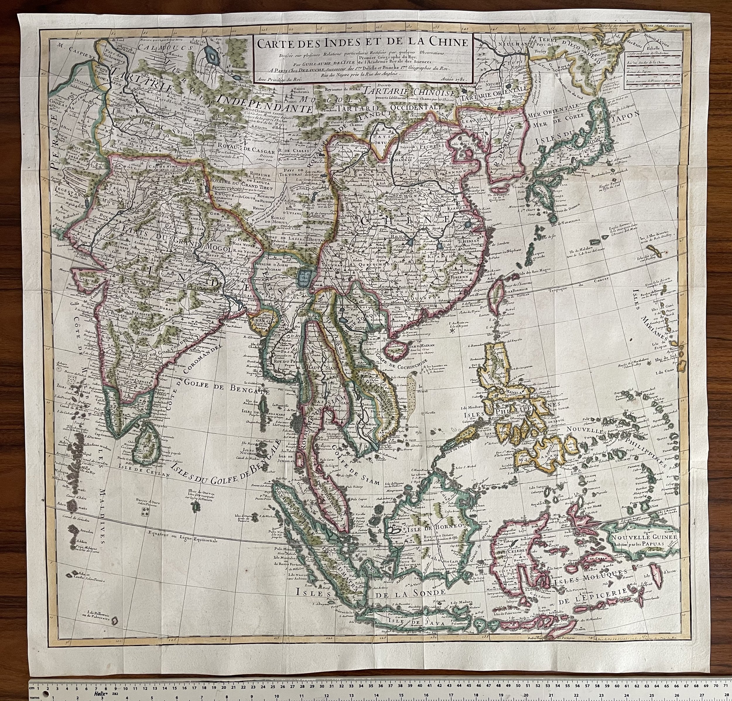
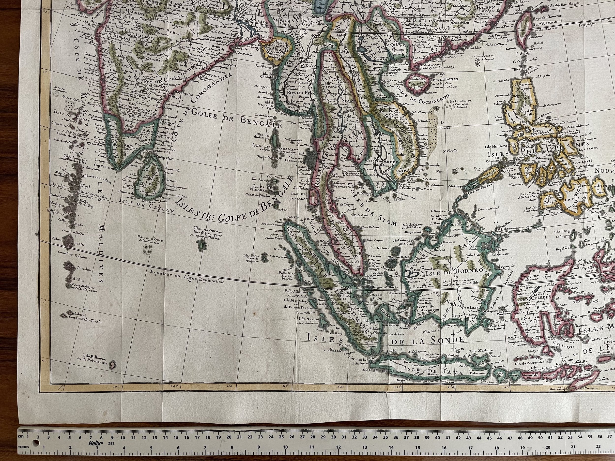
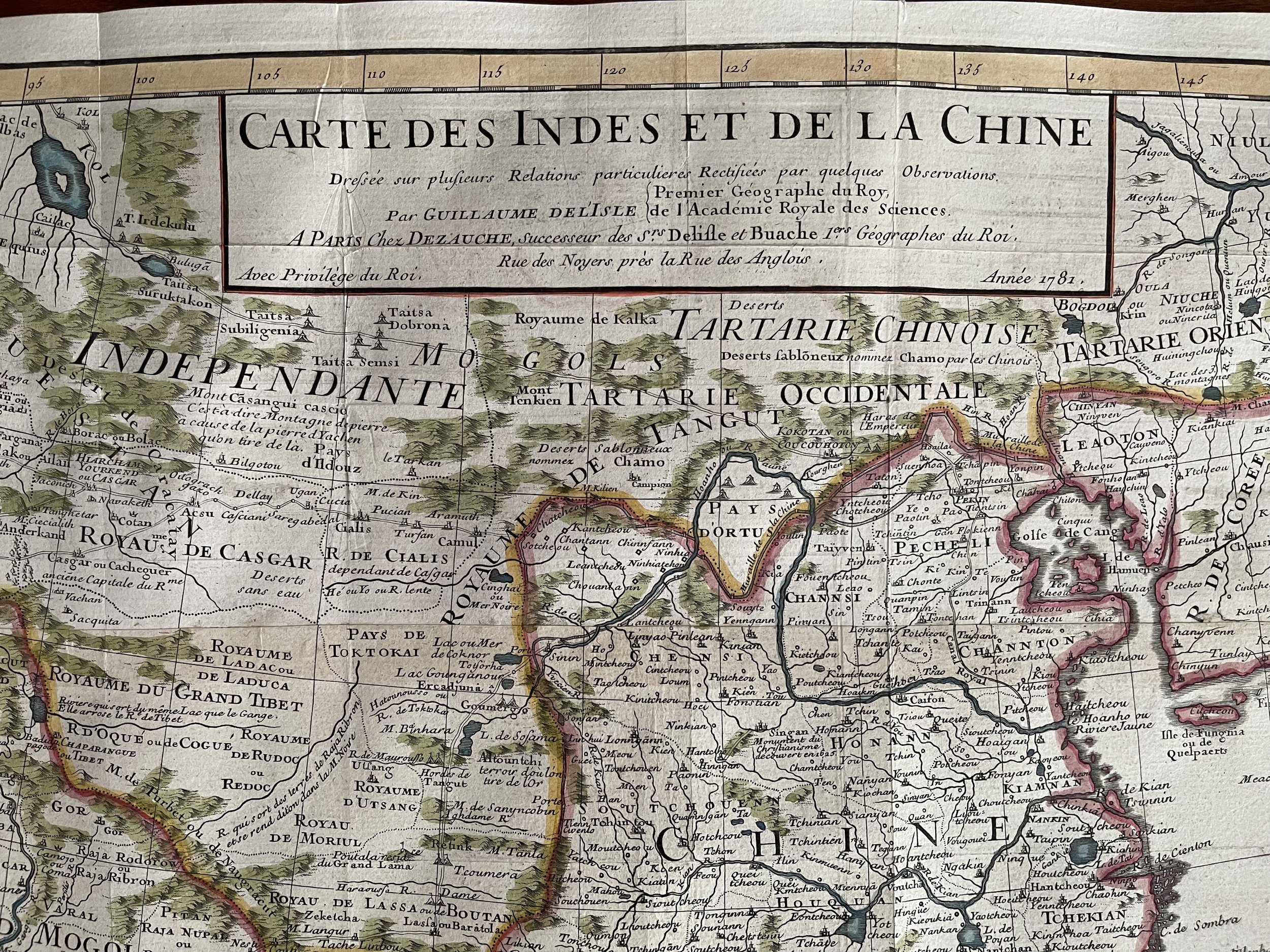
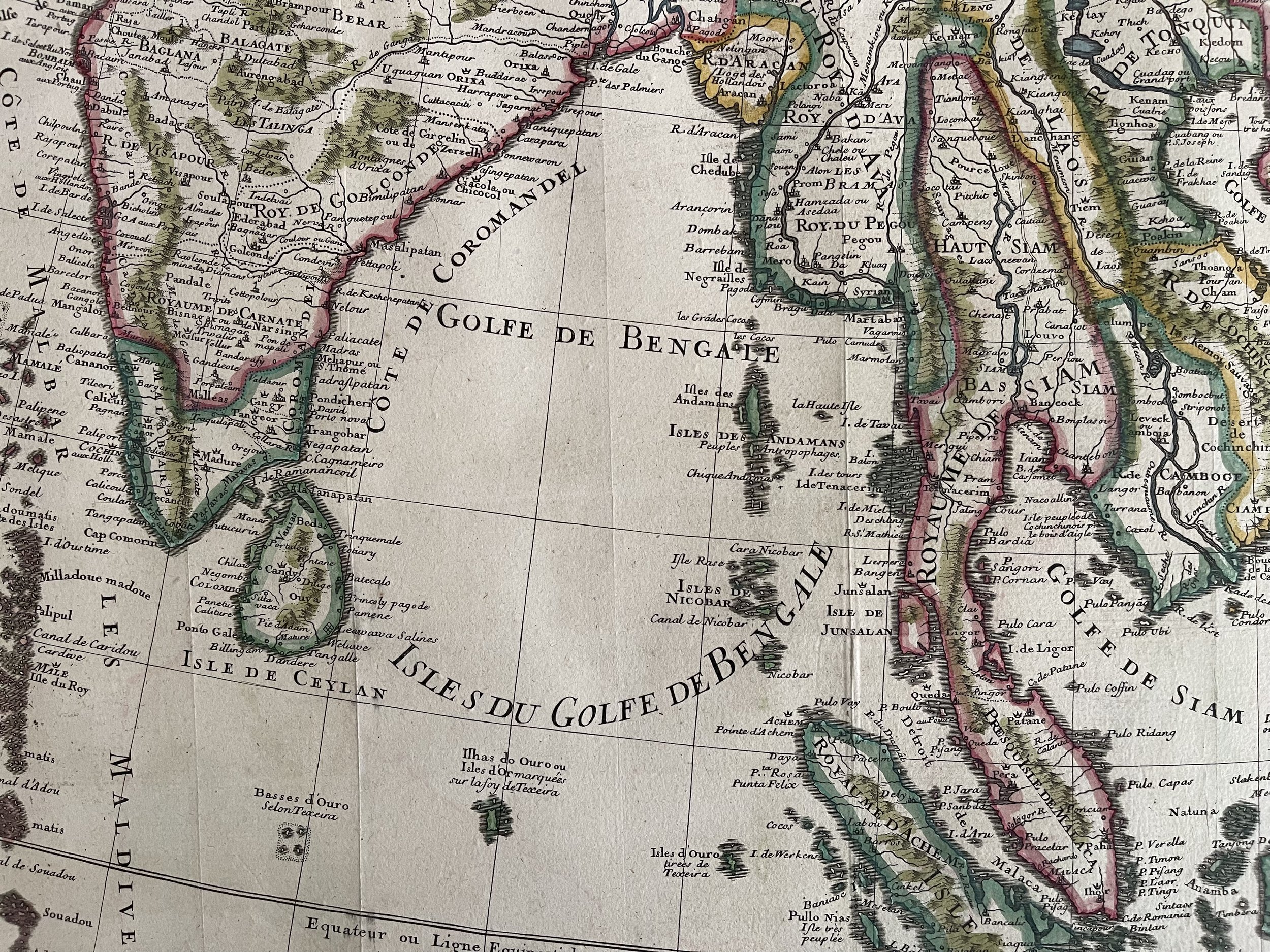
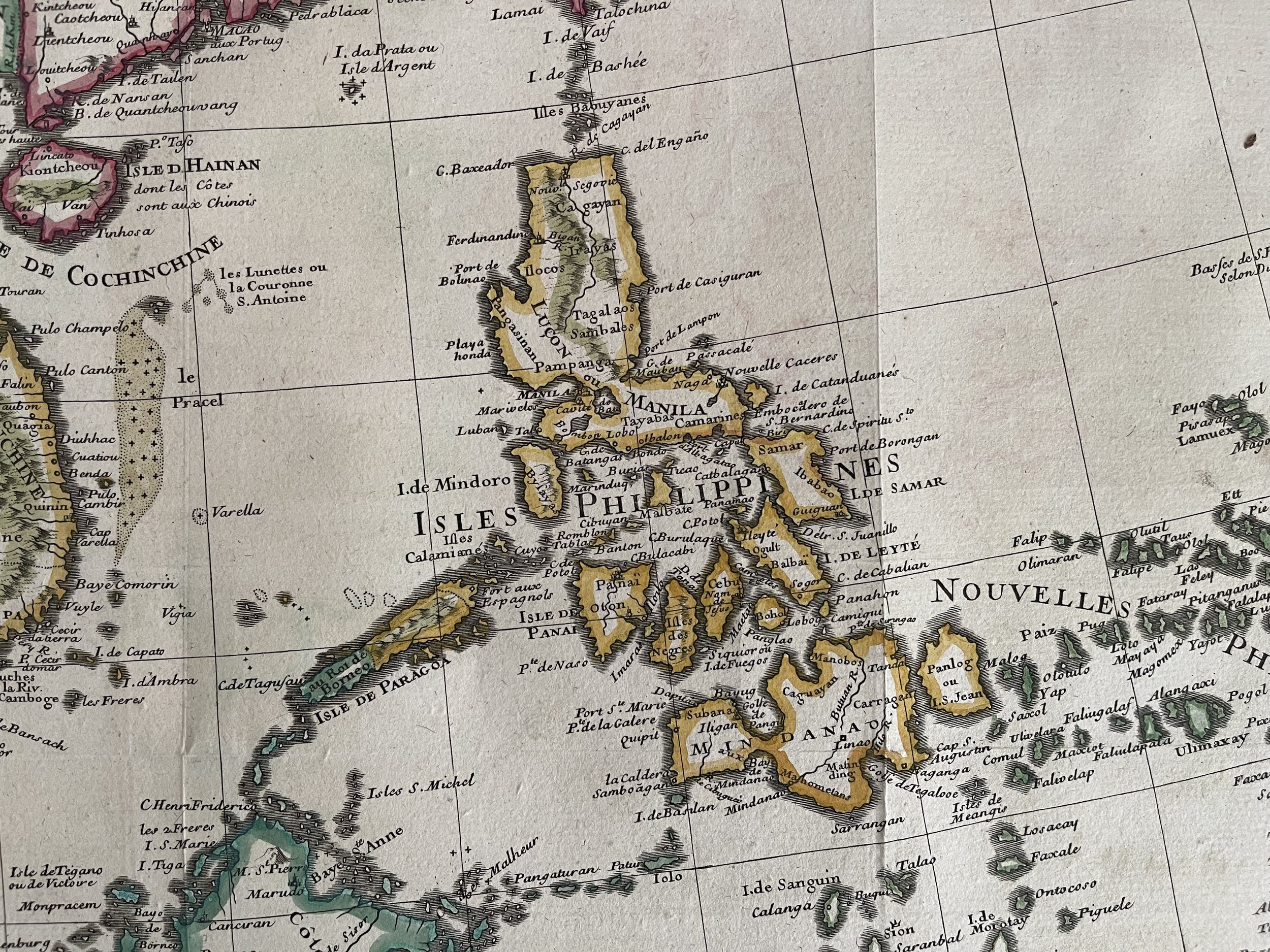
East Asia and the Indian subcontinent - Jean Claude Dezauche / Guillaume De L'Isle - Paris 1781
Stunning map in incredible condition. Fine, Detailed Map of Eastern Asia -- Shows the Sea of Korea
Notable example of this meticulously-drawn map of East Asia and the Indian subcontinent published in Paris. The map is based upon the earlier work of the famed geographer Guillaume De L'Isle and was re-issued by his son-in-law, Philippe Buache, and later by their heir, J.A. Dezauche.
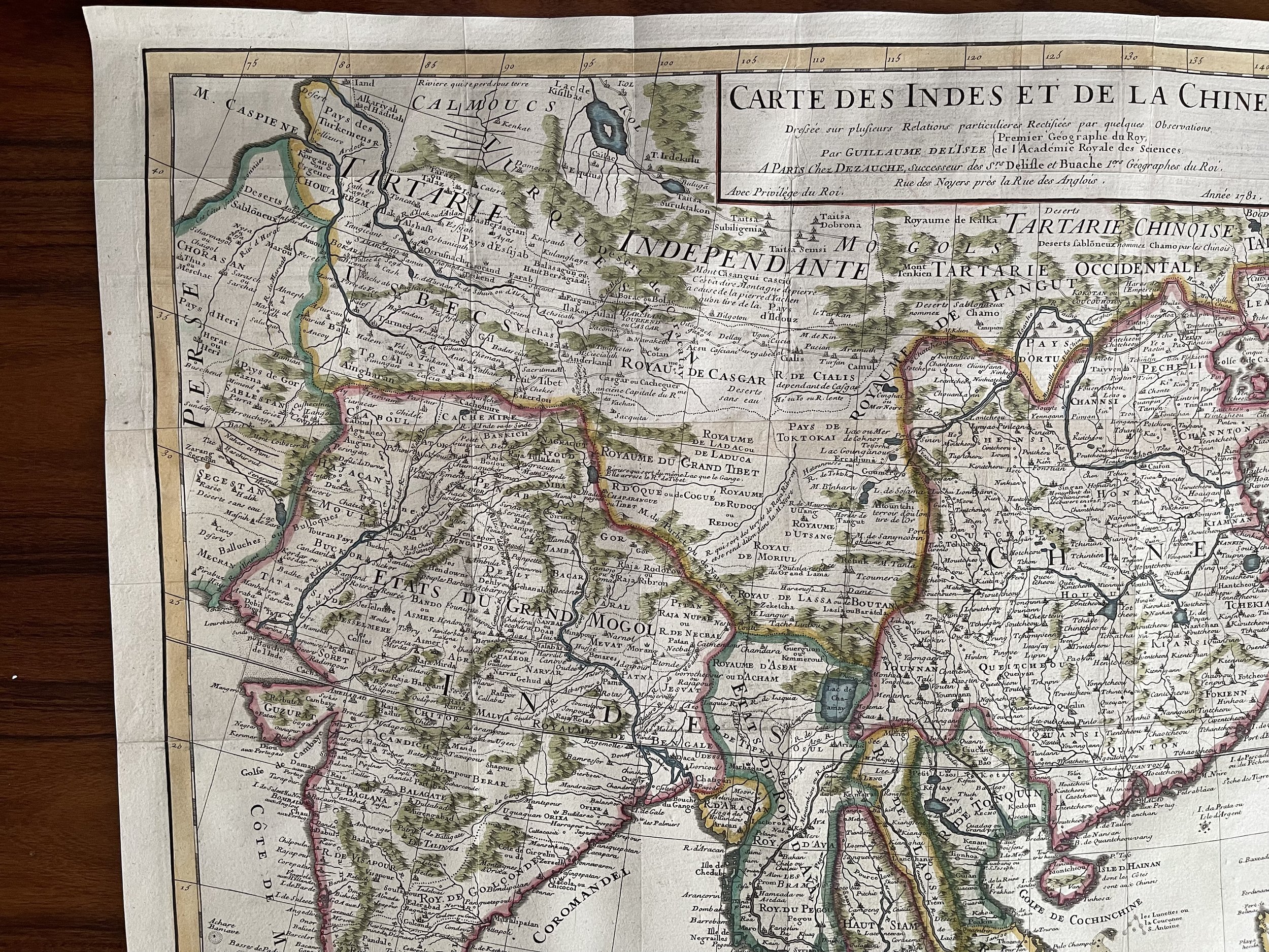
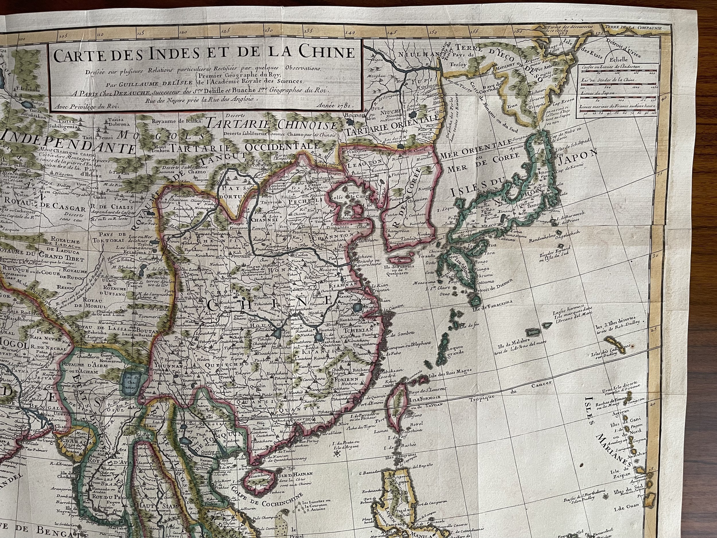
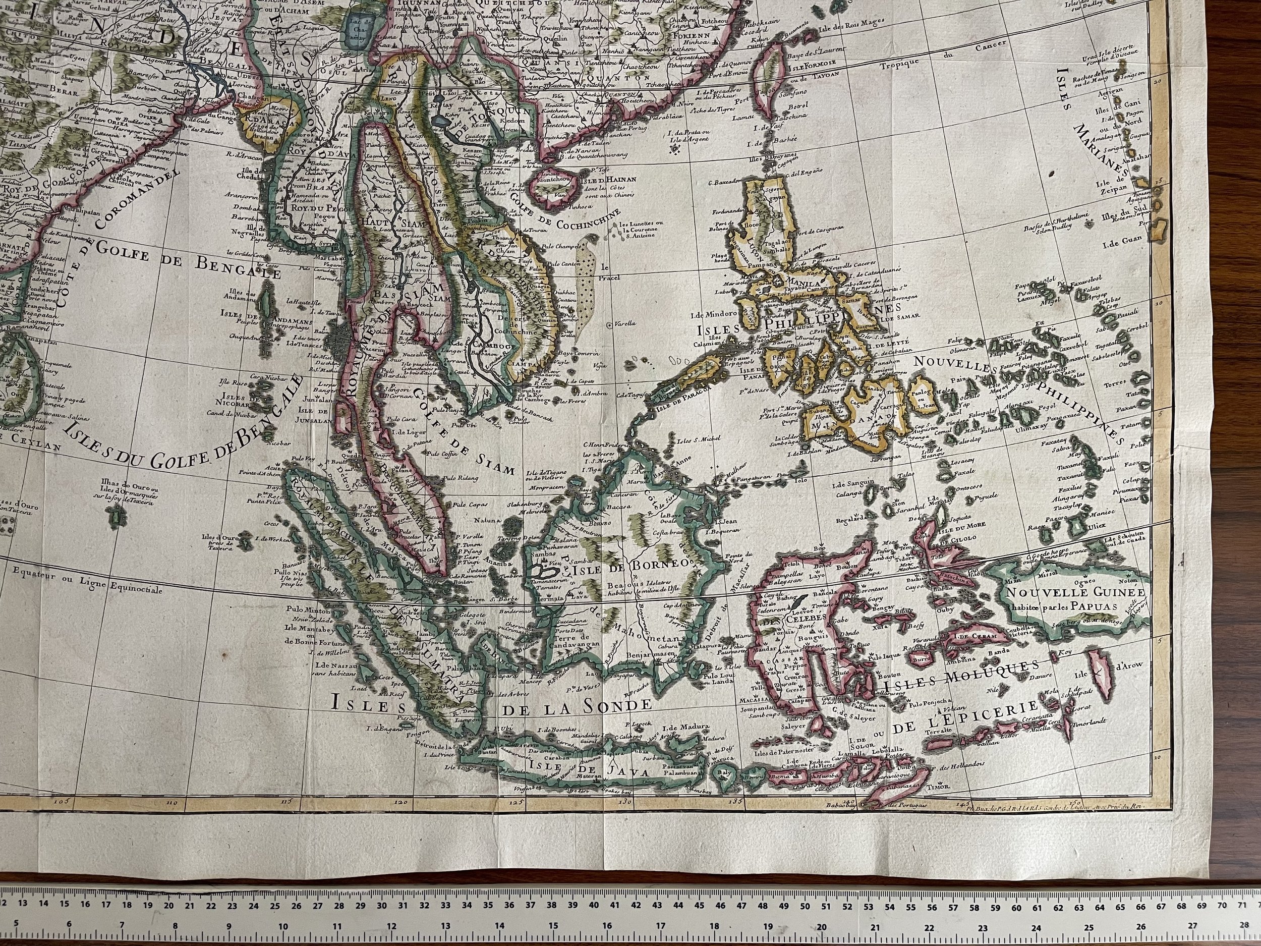
The map covers much of Asia, from China and Japan, south to New Guinea and the Moluccas, west through Malaysia and Indonesia to what is today Vietnam and Thailand, and India.
Dotted lines mark political boundaries. The map is thickly detailed with settlements, geographic features, and ethnographic notes. There is a simple title cartouche in the top center, with a quadruple scale bar in the upper right corner.
While most of the outlines of the continent appear familiar to the modern eye, the landmass north of Japan may prove surprising. Here, the “Terre de Yeco ou d’Eso.” Yeco is a reference to Jesso, a feature included on many seventeenth and eighteenth-century maps. Historically, Eso (Jesso, Yedso, Yesso) refers to the island of Hokkaido. It varies on maps from a small island to a near-continent sized mass that stretched from Asia to Alaska.
Jean Claude Dezauche ( 1745 - 1824) (fl. c. 1780 - 1838)
He acquired the stock of a number important French mapmakers. Delisle’s business was inherited by his son-in-law Philippe Buache, on his death, his widow sold his work to Jean Nicholas Buache de la Neuville, and then in 1780 Dezauche bought it from him together with work by Delisle, Jaillot and others. Dezauche, Jean-Claude
Jean-Claude Dezauche (1745 - 1824) was a French map engraver & publisher active in Paris during the first half of the 19th century. He established his own engraving firm around 1770 after having engraved music since 1762. Dezauche bought the archives of Phillipe Buache and Guillaume de L'Isle from Jean Nicholas Buache, Buache's heir, in 1780. Dezauche soon obtained a monopoly on selling the charts produced by the Dépôt de la Marine. Jean-Claude Dezuache passed his business to his son, Jean André Dezauche, upon his death, who took over selling the Dépôt de la Marine charts.
Guillaume De L’Isle
The thoroughness of the information included here, and its density, is characteristic of Guillaume De L’Isle, who originally drafted the map. Guillaume De L'Isle (1675-1726) is probably the greatest figure in French cartography. Having learned geography from his father Claude, by the age of eight or nine he could draw maps to demonstrate ancient history. He studied mathematics and astronomy under Cassini, from whom he received a superb grounding in scientific cartography—the hallmark of his work. His first atlas was published in ca. 1700. In 1702 he was elected a member of the Academie Royale des Sciences and in 1718 he became Premier Geographe du Roi.
De L'Isle's work was important as marking a transition from the maps of the Dutch school, which were highly decorative and artistically-orientated, to a more scientific approach. He reduced the importance given to the decorative elements in maps, and emphasized the scientific base on which they were constructed. His maps of the newly explored parts of the world reflect the most up-to-date information available and did not contain fanciful detail in the absence of solid information. It can be fairly said that he was truly the father of the modern school of cartography at the commercial level.
De L’Isle also played a prominent part in the recalculation of latitude and longitude, based on the most recent celestial observations. His major contribution was in collating and incorporating this latitudinal and longitudinal information in his maps, setting a new standard of accuracy, quickly followed by many of his contemporaries. Guillaume De L’Isle’s work was widely copied by other mapmakers of the period, including Chatelain, Covens & Mortier (as seen here), and Albrizzi.
Stunning map in incredible condition. Fine, Detailed Map of Eastern Asia -- Shows the Sea of Korea
Notable example of this meticulously-drawn map of East Asia and the Indian subcontinent published in Paris. The map is based upon the earlier work of the famed geographer Guillaume De L'Isle and was re-issued by his son-in-law, Philippe Buache, and later by their heir, J.A. Dezauche.
The map covers much of Asia, from China and Japan, south to New Guinea and the Moluccas, west through Malaysia and Indonesia to what is today Vietnam and Thailand, and India.
Dotted lines mark political boundaries. The map is thickly detailed with settlements, geographic features, and ethnographic notes. There is a simple title cartouche in the top center, with a quadruple scale bar in the upper right corner.
While most of the outlines of the continent appear familiar to the modern eye, the landmass north of Japan may prove surprising. Here, the “Terre de Yeco ou d’Eso.” Yeco is a reference to Jesso, a feature included on many seventeenth and eighteenth-century maps. Historically, Eso (Jesso, Yedso, Yesso) refers to the island of Hokkaido. It varies on maps from a small island to a near-continent sized mass that stretched from Asia to Alaska.
Jean Claude Dezauche ( 1745 - 1824) (fl. c. 1780 - 1838)
He acquired the stock of a number important French mapmakers. Delisle’s business was inherited by his son-in-law Philippe Buache, on his death, his widow sold his work to Jean Nicholas Buache de la Neuville, and then in 1780 Dezauche bought it from him together with work by Delisle, Jaillot and others. Dezauche, Jean-Claude
Jean-Claude Dezauche (1745 - 1824) was a French map engraver & publisher active in Paris during the first half of the 19th century. He established his own engraving firm around 1770 after having engraved music since 1762. Dezauche bought the archives of Phillipe Buache and Guillaume de L'Isle from Jean Nicholas Buache, Buache's heir, in 1780. Dezauche soon obtained a monopoly on selling the charts produced by the Dépôt de la Marine. Jean-Claude Dezuache passed his business to his son, Jean André Dezauche, upon his death, who took over selling the Dépôt de la Marine charts.
Guillaume De L’Isle
The thoroughness of the information included here, and its density, is characteristic of Guillaume De L’Isle, who originally drafted the map. Guillaume De L'Isle (1675-1726) is probably the greatest figure in French cartography. Having learned geography from his father Claude, by the age of eight or nine he could draw maps to demonstrate ancient history. He studied mathematics and astronomy under Cassini, from whom he received a superb grounding in scientific cartography—the hallmark of his work. His first atlas was published in ca. 1700. In 1702 he was elected a member of the Academie Royale des Sciences and in 1718 he became Premier Geographe du Roi.
De L'Isle's work was important as marking a transition from the maps of the Dutch school, which were highly decorative and artistically-orientated, to a more scientific approach. He reduced the importance given to the decorative elements in maps, and emphasized the scientific base on which they were constructed. His maps of the newly explored parts of the world reflect the most up-to-date information available and did not contain fanciful detail in the absence of solid information. It can be fairly said that he was truly the father of the modern school of cartography at the commercial level.
De L’Isle also played a prominent part in the recalculation of latitude and longitude, based on the most recent celestial observations. His major contribution was in collating and incorporating this latitudinal and longitudinal information in his maps, setting a new standard of accuracy, quickly followed by many of his contemporaries. Guillaume De L’Isle’s work was widely copied by other mapmakers of the period, including Chatelain, Covens & Mortier (as seen here), and Albrizzi.
Code : A418
Cartographer : Cartographer / Engraver / Publisher: Guillaume De L'Isle and was re-issued by his son-in-law, Philippe Buache, and later by their heir, J.A. Dezauche
Date : Publication Place / Date - Paris 1781
Size : Sheet size: 25 x 26 inches
Availability : Available
Type - Genuine Antique
Grading - A
Tracked postage, in tubular casement. Please contact me for postal quotation outside of the UK.