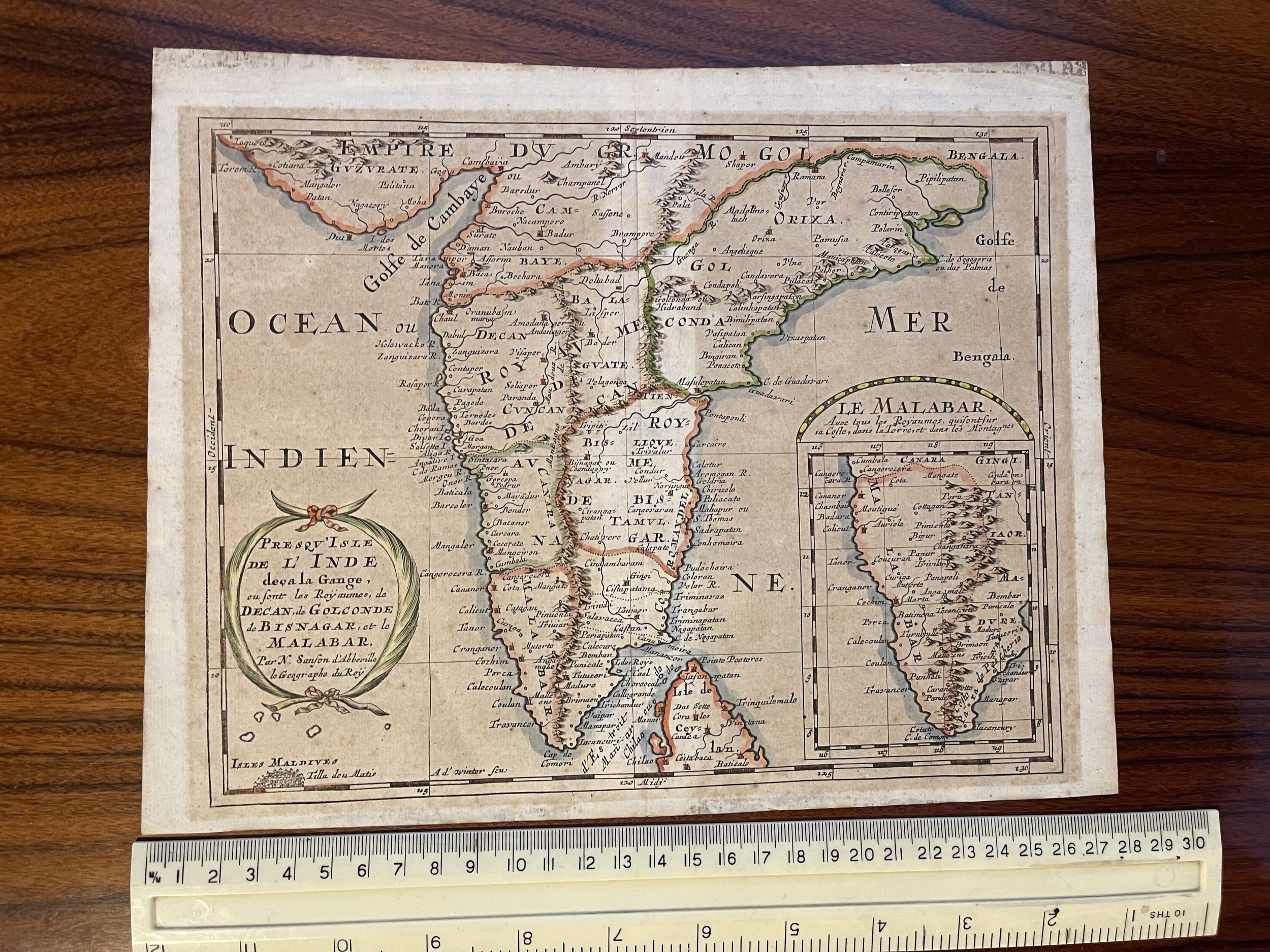

Indian Peninsula and Malabar - L'Inde Malabar - Nicolas SANSON - 1683
This is Nicolas Sanson's 1653 map of the Indian Peninsula, re-engraved for its first Dutch edition of 1683.
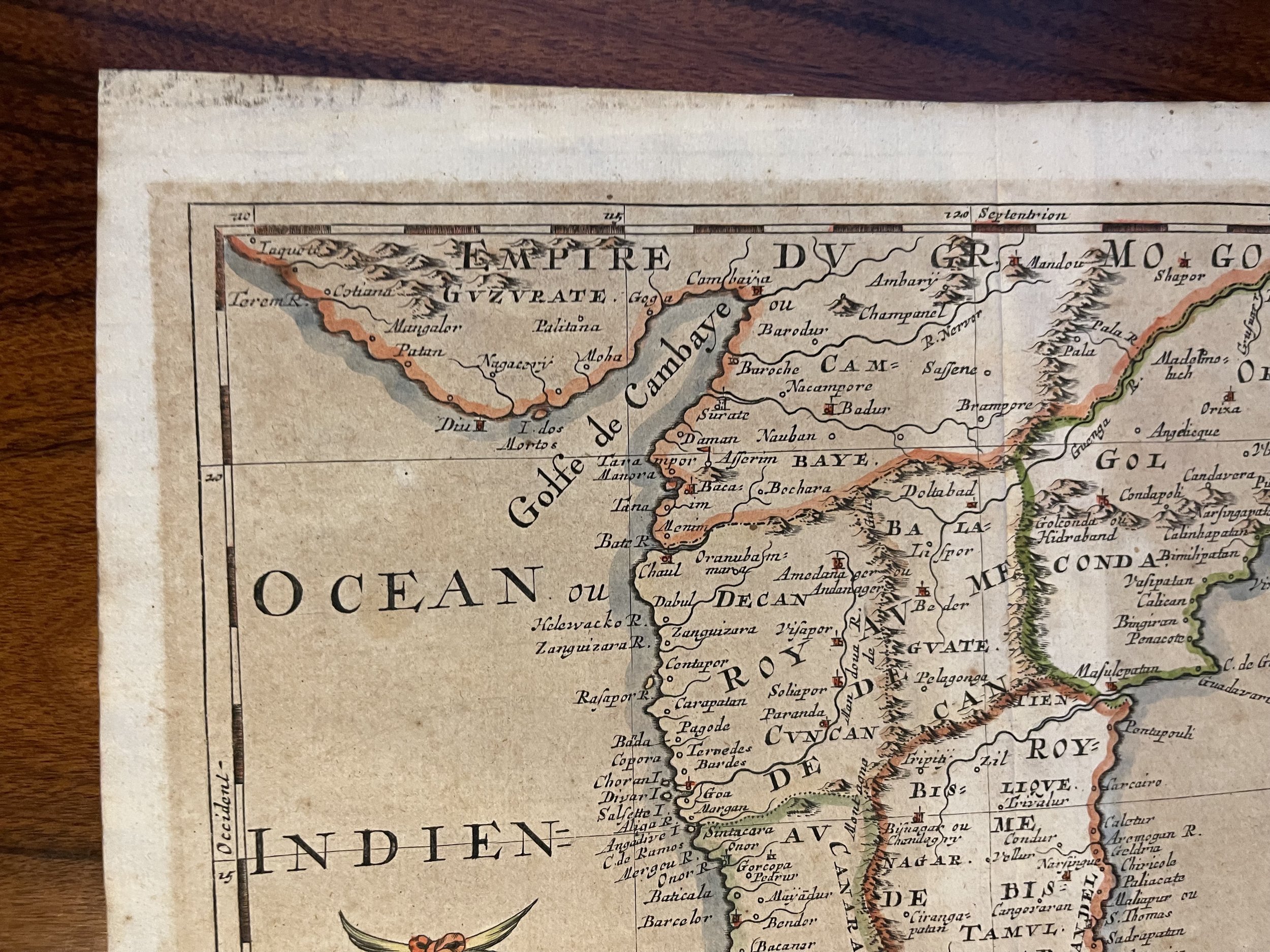
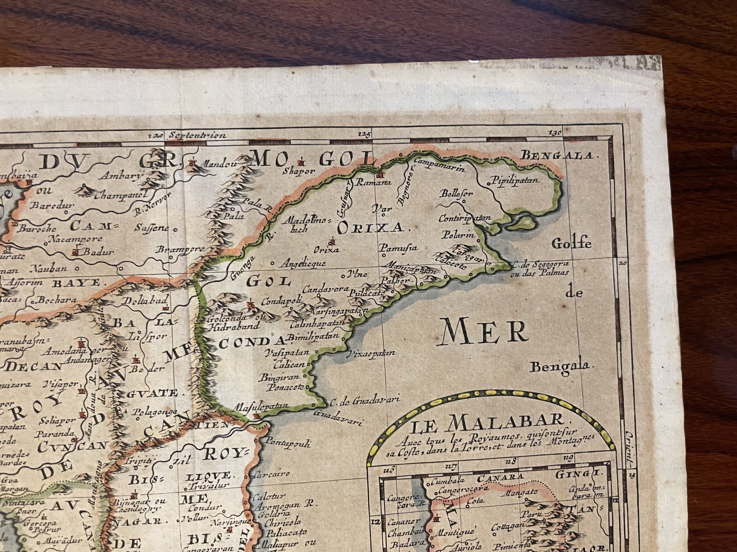
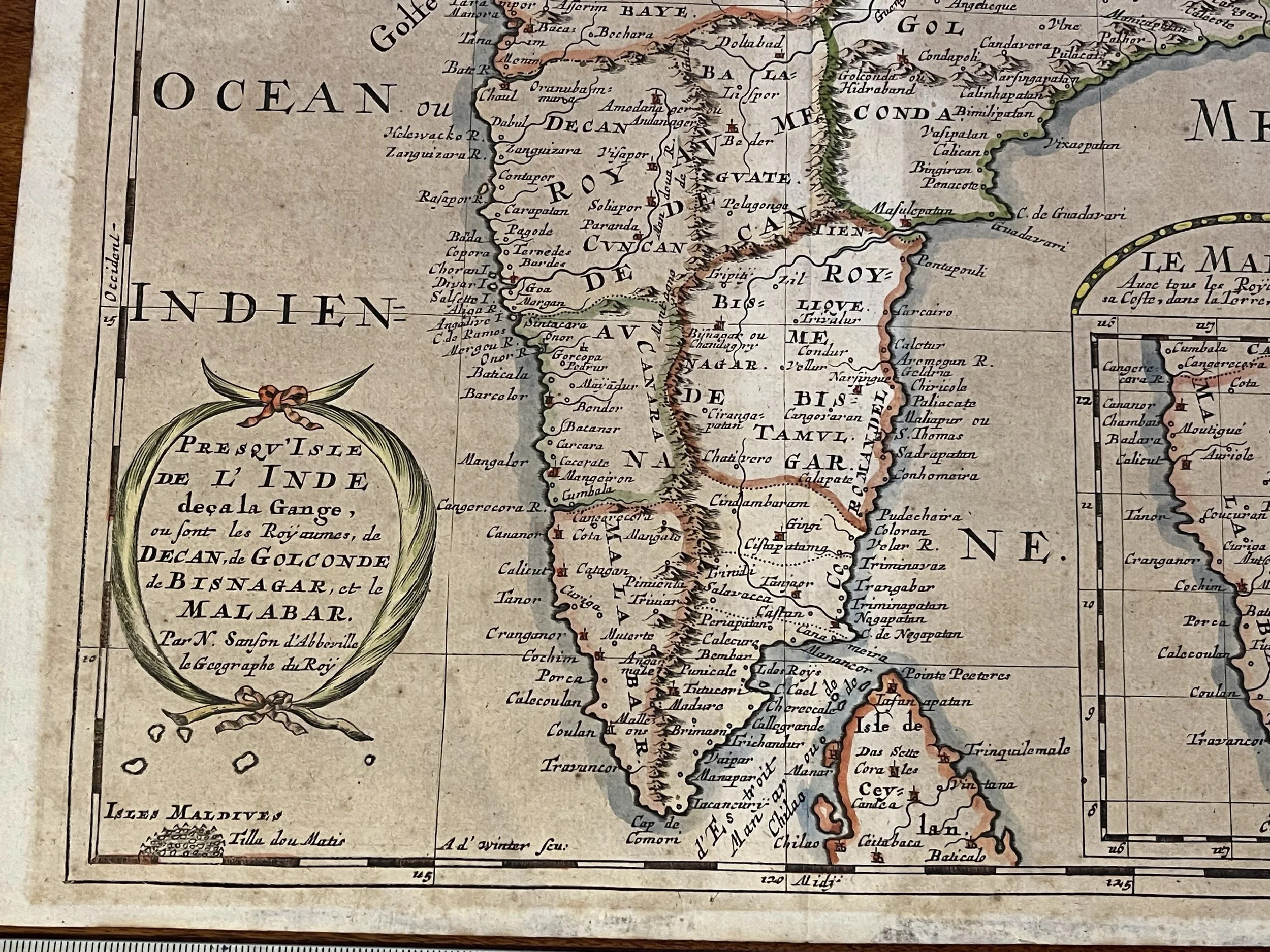
The map extends from Guzarat and the Bay of Bengal in the north to Cape Comorin and the northern part of Sri Lanka in the south. Coverage includes the northernmost atoll of the Maldives, Thiladhummathi (Tilla dou Matis on the map) An inset map in the lower right focuses on the Malabar coast. Sanson provide copious detail throughout, despite European geographer's predominant ignorance of Indian geography away from the coast - particularly with respect to the mountain ranges depicted here. Nevertheless, the major southern regions of the Deccan plateau and the Malabar coast are depicted. The southeastern region i named Bisnagar, a convoluted Europeanization of the Vijayanagara Empire, which, despite being a power in the 16th century, was completely ruined by Sanson's day. The Golconda Sultanate, in the northeast of the map, with its capital at Hyderabad (Hidraband on the map), was a current power. It would last until the Mughal empire conquered the Deccan in 1687.
The International Edition
Sanson's small-format atlas, published in four volumes each dedicated to its own continent, had proved popular in Paris. In 1683, an edition collecting all four parts was published by Ribbius in Utrecht. The text was written by historian and exoticist Simon de Vries, and the maps were newly-engraved by Anthonie de Winter. They were faithful and skilled copies of those engraved for Sanson in Paris.
Publication History and Census
This map was initially produced in 1653 for inclusion in Sanson's L'Asie En Plusieurs Cartes Nouvelles Et Exactes; Et En Divers Traittés De Geographie et D'Histoire. It was re-engraved in Utrecht for inclusion in the 1683 Geographische en historische beschryvingh der vier bekende werelds-deelen Europa, Asia, Africa en America, published by Ribbius. The present example corresponds with this first, 1683 state of the map. In 1700, when the maps were republished in Amsterdam by François Halma, the plate would be reworked, with more boldly engraved borders. The atlas is well represented in institutional collections. The separate map is not listed in OCLC with reference to the Utrecht edition, but it is abundantly possible that some of the many examples listed as Paris or Amsterdam printings are misidentified.
Nicolas Sanson (December 20, 1600 - July 7, 1667) and his descendants were the most influential French cartographers of the 17th century and laid the groundwork for the Golden Age of French Cartography. Sanson was born in Picardy, but his family was of Scottish Descent. He studied with the Jesuit Fathers at Amiens. Sanson started his career as a historian where, it is said, he turned to cartography as a way to illustrate his historical studies. In the course of his research some of his fine maps came to the attention of King Louis XIII who, admiring the quality of his work, appointed Sanson Geographe Ordinaire du Roi.
Sun bleaching accross the entire surface of the map (originally framed) but there is no loss of colour or detail.
This is Nicolas Sanson's 1653 map of the Indian Peninsula, re-engraved for its first Dutch edition of 1683.
The map extends from Guzarat and the Bay of Bengal in the north to Cape Comorin and the northern part of Sri Lanka in the south. Coverage includes the northernmost atoll of the Maldives, Thiladhummathi (Tilla dou Matis on the map) An inset map in the lower right focuses on the Malabar coast. Sanson provide copious detail throughout, despite European geographer's predominant ignorance of Indian geography away from the coast - particularly with respect to the mountain ranges depicted here. Nevertheless, the major southern regions of the Deccan plateau and the Malabar coast are depicted. The southeastern region i named Bisnagar, a convoluted Europeanization of the Vijayanagara Empire, which, despite being a power in the 16th century, was completely ruined by Sanson's day. The Golconda Sultanate, in the northeast of the map, with its capital at Hyderabad (Hidraband on the map), was a current power. It would last until the Mughal empire conquered the Deccan in 1687.
The International Edition
Sanson's small-format atlas, published in four volumes each dedicated to its own continent, had proved popular in Paris. In 1683, an edition collecting all four parts was published by Ribbius in Utrecht. The text was written by historian and exoticist Simon de Vries, and the maps were newly-engraved by Anthonie de Winter. They were faithful and skilled copies of those engraved for Sanson in Paris.
Publication History and Census
This map was initially produced in 1653 for inclusion in Sanson's L'Asie En Plusieurs Cartes Nouvelles Et Exactes; Et En Divers Traittés De Geographie et D'Histoire. It was re-engraved in Utrecht for inclusion in the 1683 Geographische en historische beschryvingh der vier bekende werelds-deelen Europa, Asia, Africa en America, published by Ribbius. The present example corresponds with this first, 1683 state of the map. In 1700, when the maps were republished in Amsterdam by François Halma, the plate would be reworked, with more boldly engraved borders. The atlas is well represented in institutional collections. The separate map is not listed in OCLC with reference to the Utrecht edition, but it is abundantly possible that some of the many examples listed as Paris or Amsterdam printings are misidentified.
Nicolas Sanson (December 20, 1600 - July 7, 1667) and his descendants were the most influential French cartographers of the 17th century and laid the groundwork for the Golden Age of French Cartography. Sanson was born in Picardy, but his family was of Scottish Descent. He studied with the Jesuit Fathers at Amiens. Sanson started his career as a historian where, it is said, he turned to cartography as a way to illustrate his historical studies. In the course of his research some of his fine maps came to the attention of King Louis XIII who, admiring the quality of his work, appointed Sanson Geographe Ordinaire du Roi.
Sun bleaching accross the entire surface of the map (originally framed) but there is no loss of colour or detail.
Code : A236
Cartographer : Cartographer / Engraver / Publisher: Nicolas Sanson
Date : Publication Place / Date - 1683 Approx
Size : Sheet size: Image Size: 7.5 x 9.75 in (19.05 x 24.765 cm)
Availability : Available
Type - Genuine Antique
Grading - B-
Tracked postage, in tubular casement. Please contact me for postal quotation outside of the UK.