
Southern Hemisphere Discoveries Antique Copper Engraved World Map - Jacques-Nicolas Bellin (Geographer) / Jacques Renaud Benard (Engraver) - 1785
Description
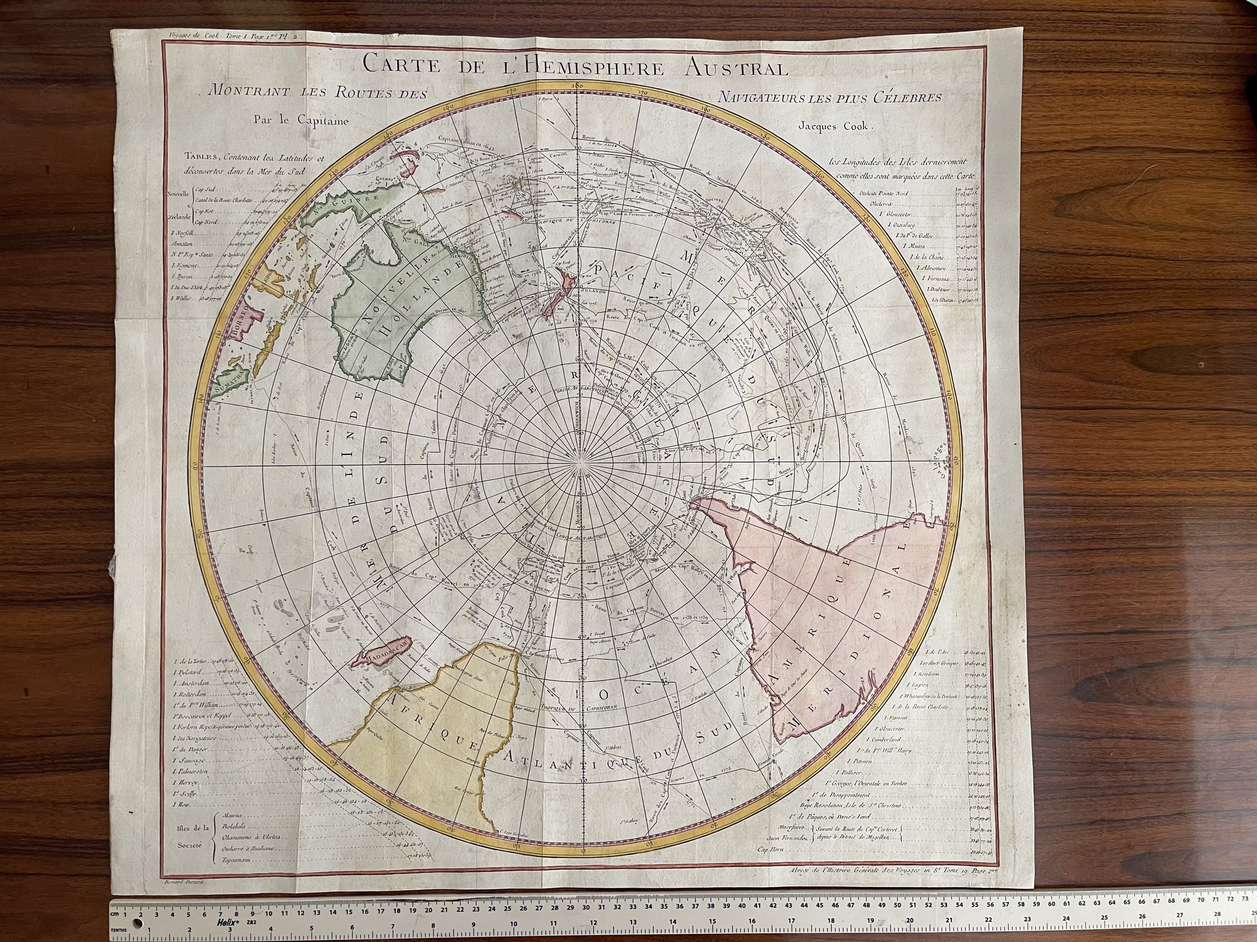
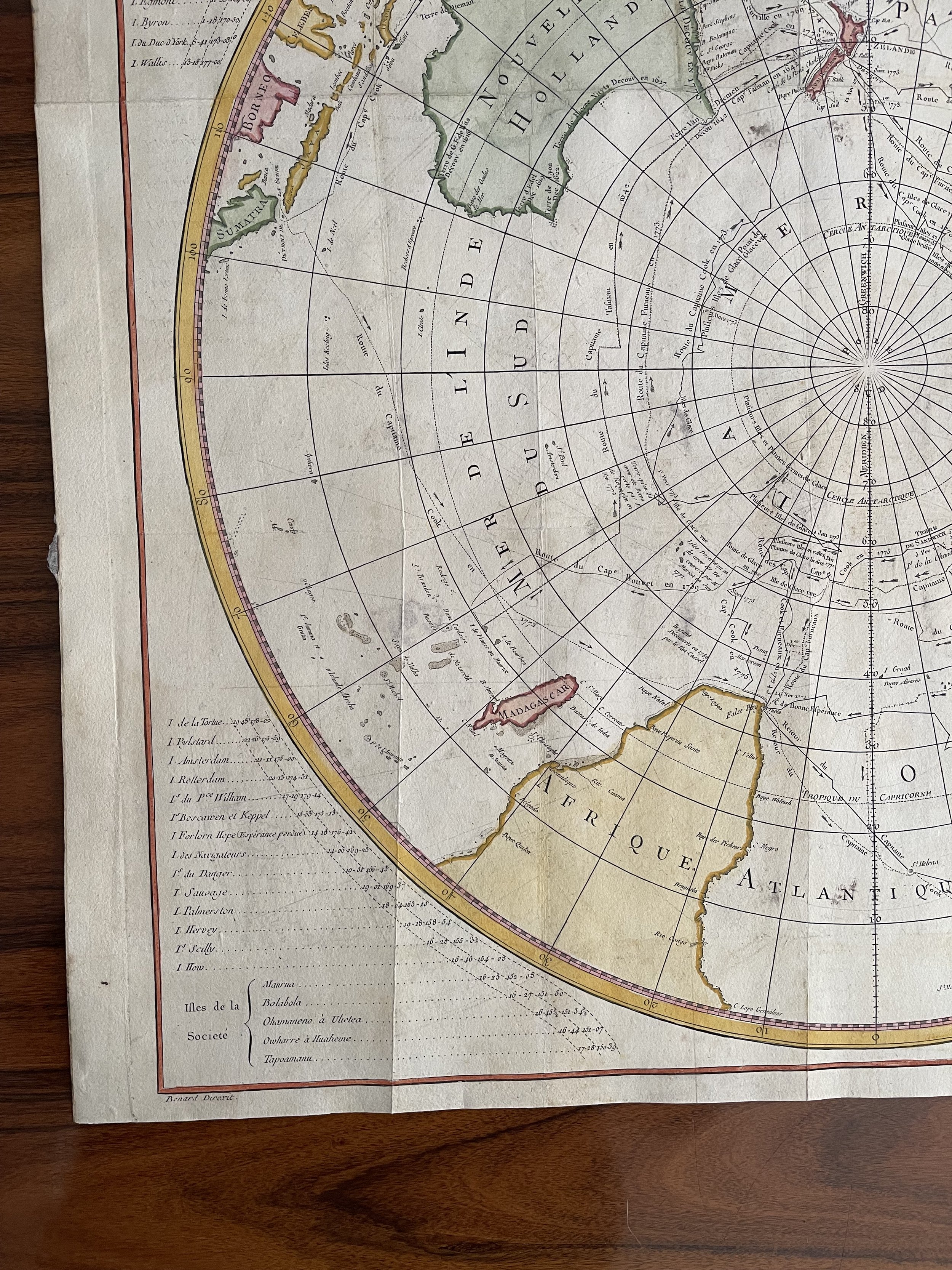
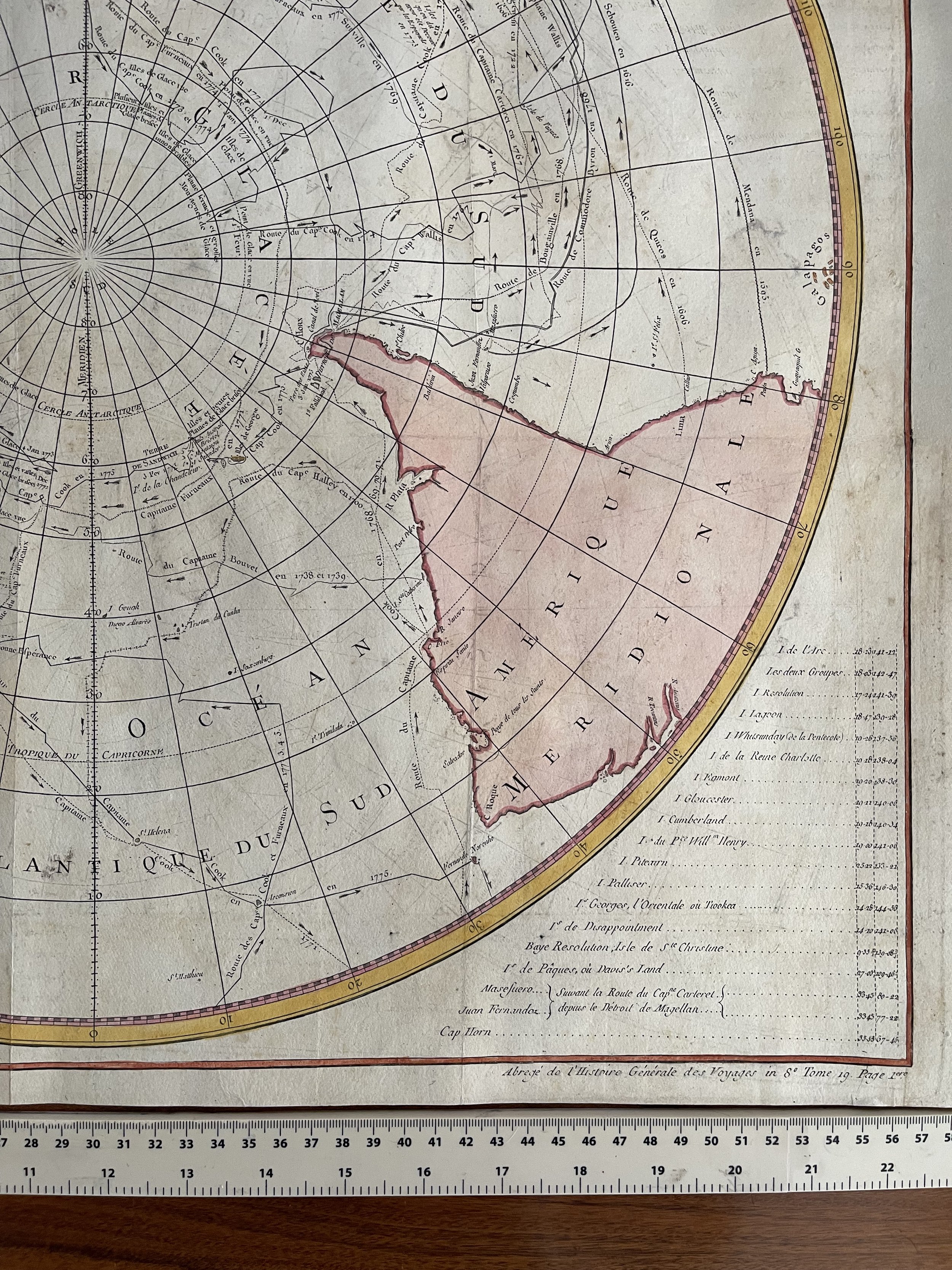
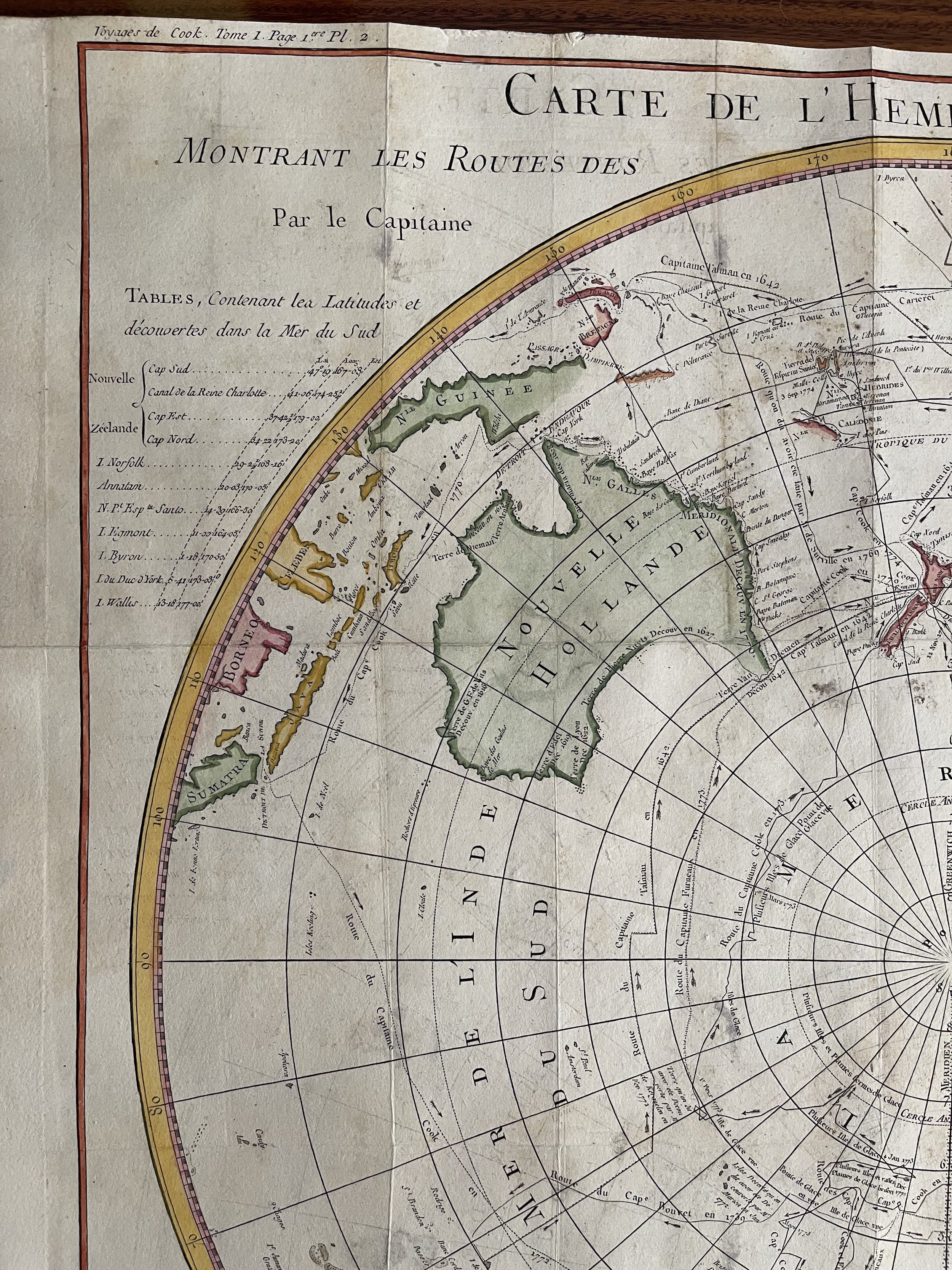
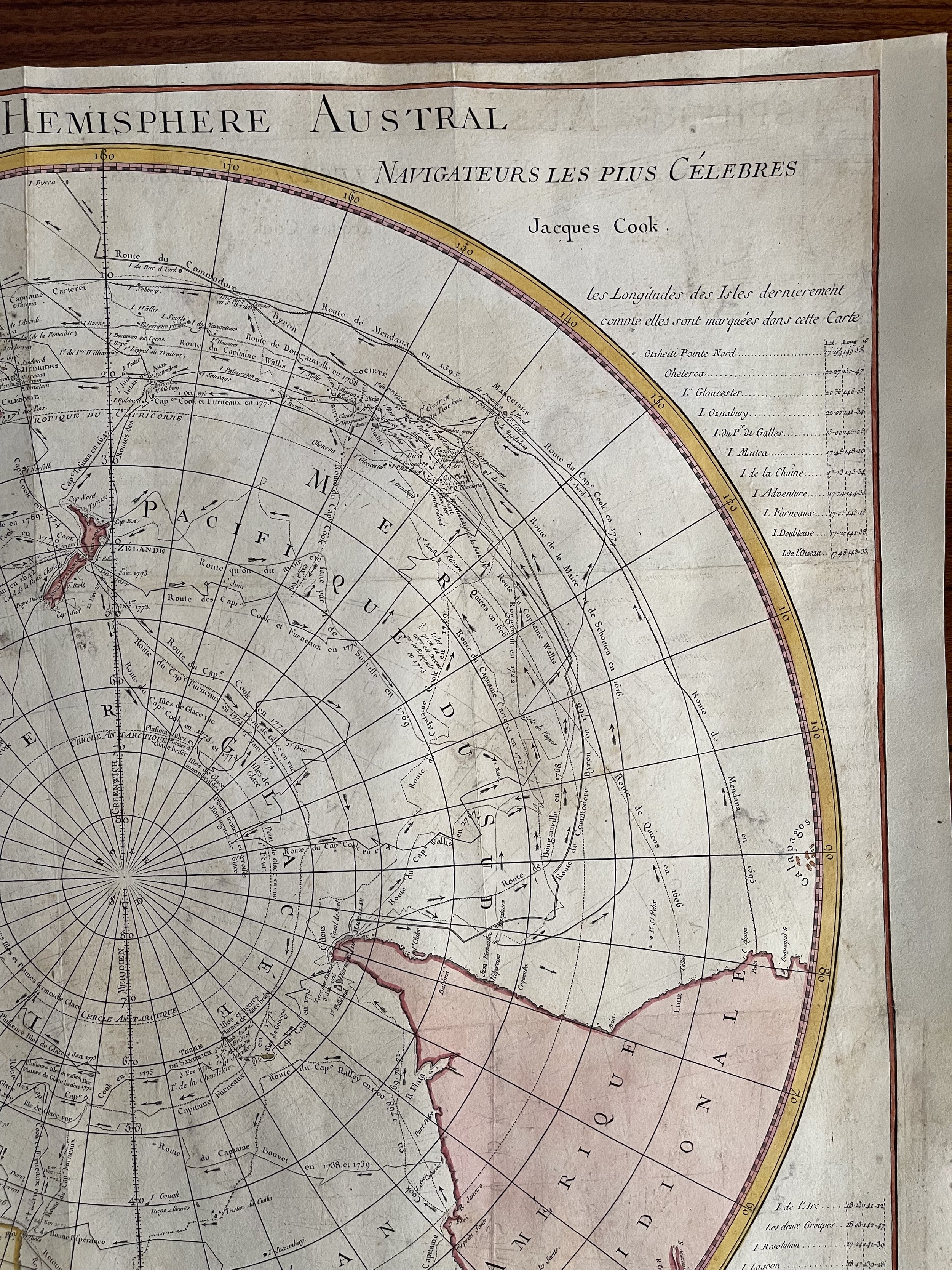
Carte de l'Hemisphere Austral Montrant les Routes des Navigateurs les Plus Célebres par le Captaine Jacques Cook. Description: Striking and highly detailed fine unusual 1785 Jacques-Nicolas Bellin's copper engraved map of the Southern Hemisphere, including New Zealand, Australia, New Guinea, Borneo, Madagascar, part of Africa and South America and more.
This map was created to detail Jacques Cook’s voyages in the region and also shows the tracks of the major voyages of exploration in the Southern Hemisphere from 1595 to 1775. Including the voyages of Mendana (1595), Quiros (1606), Le Maire and Schoeten (1616), Tasman (1642), Halley (1700), Roggewein (1722), Bouvet (1738-39), Carteret (1767), Wallis (1767), Byron (1768), Bouganville (1768) Cook (1770-75), and others.
This plate has been published in the First French edition of Abbè Presvost’s “Histoire Générale des Voyages”, published by Didot at Paris.. Source: The Histoire Géneral des Voyages was a monumental eighteenth century general history divided according to geographic region. The original volumes were written by Antoine François Prévost d'Exiles, a French author, novelist, theologian, natural historian, and a priest of the Jesuit and Benedictine orders, but continued by numerous other authors after Prévost's death. The earliest books mostly deal with the Far East and South-East Asia, providing a general history of their regions, kingdoms, customs, culture, costumes, natural phenomena and religious beliefs. Much of Prévost's information is derived from the reports of Jesuit missionaries, Portuguese merchants, and famous explorers, from Marco Polo to Sir Francis Drake. Although written in French, the popularity of the Histoire among Dutch audiences meant that many of the illustrative plates and maps published to accompany the work were either re-engraved or subtitled in Dutch by the engraver Jakob van der Schley. Prévost himself had travelled widely throughout the Netherlands, launching his literary career in Amsterdam and the Hague after fleeing the Benedictines in France. Prevost's work on China, and indeed many of van der Schley's plates, owe a great debt to Johan Nieuhoff (1618-1672) , a Dutch traveller who explored much of China, India, and Brazil while in the employ of the Dutch East India Company. Nieuhoff wrote extensively, with a particular focus on China, for his memoirs, and his numerous drawings of Chinese places and people were much copied by later engravers for numerous works of Chinese interest. Nieuhoff's own book became a major source of inspiration for eighteenth century chinoiserie, and are amongst the first western illustrations to depict the Chinese people in a manner which was based upon personal observation rather than the tradition of oriental fantasy.
Date: 1785 ( undated )
Dimension: Paper size approx.: cm 58,8 x 55,9
Condition: Very strong and dark impression on good paper. Paper with chains and wiremarks. Map contemporary handcolored. Margin to the top missing. Small lower margin cut partially very shortly at the left side. Wide lateral margins. Right lateral margin partially missing to the top and redone. Small foxing. Small tears restored. Map professionally washed and restored. Plate folded. Conditions are as you can see in the images.
Description
Carte de l'Hemisphere Austral Montrant les Routes des Navigateurs les Plus Célebres par le Captaine Jacques Cook. Description: Striking and highly detailed fine unusual 1785 Jacques-Nicolas Bellin's copper engraved map of the Southern Hemisphere, including New Zealand, Australia, New Guinea, Borneo, Madagascar, part of Africa and South America and more.
This map was created to detail Jacques Cook’s voyages in the region and also shows the tracks of the major voyages of exploration in the Southern Hemisphere from 1595 to 1775. Including the voyages of Mendana (1595), Quiros (1606), Le Maire and Schoeten (1616), Tasman (1642), Halley (1700), Roggewein (1722), Bouvet (1738-39), Carteret (1767), Wallis (1767), Byron (1768), Bouganville (1768) Cook (1770-75), and others.
This plate has been published in the First French edition of Abbè Presvost’s “Histoire Générale des Voyages”, published by Didot at Paris.. Source: The Histoire Géneral des Voyages was a monumental eighteenth century general history divided according to geographic region. The original volumes were written by Antoine François Prévost d'Exiles, a French author, novelist, theologian, natural historian, and a priest of the Jesuit and Benedictine orders, but continued by numerous other authors after Prévost's death. The earliest books mostly deal with the Far East and South-East Asia, providing a general history of their regions, kingdoms, customs, culture, costumes, natural phenomena and religious beliefs. Much of Prévost's information is derived from the reports of Jesuit missionaries, Portuguese merchants, and famous explorers, from Marco Polo to Sir Francis Drake. Although written in French, the popularity of the Histoire among Dutch audiences meant that many of the illustrative plates and maps published to accompany the work were either re-engraved or subtitled in Dutch by the engraver Jakob van der Schley. Prévost himself had travelled widely throughout the Netherlands, launching his literary career in Amsterdam and the Hague after fleeing the Benedictines in France. Prevost's work on China, and indeed many of van der Schley's plates, owe a great debt to Johan Nieuhoff (1618-1672) , a Dutch traveller who explored much of China, India, and Brazil while in the employ of the Dutch East India Company. Nieuhoff wrote extensively, with a particular focus on China, for his memoirs, and his numerous drawings of Chinese places and people were much copied by later engravers for numerous works of Chinese interest. Nieuhoff's own book became a major source of inspiration for eighteenth century chinoiserie, and are amongst the first western illustrations to depict the Chinese people in a manner which was based upon personal observation rather than the tradition of oriental fantasy.
Date: 1785 ( undated )
Dimension: Paper size approx.: cm 58,8 x 55,9
Condition: Very strong and dark impression on good paper. Paper with chains and wiremarks. Map contemporary handcolored. Margin to the top missing. Small lower margin cut partially very shortly at the left side. Wide lateral margins. Right lateral margin partially missing to the top and redone. Small foxing. Small tears restored. Map professionally washed and restored. Plate folded. Conditions are as you can see in the images.
Code : A754
Cartographer : Cartographer / engraver: Jacques-Nicolas Bellin / Captain Cook.
Date : 1785
Size : Sheet size: 58,8 x 55,9 cm
Availability : Available
Type - Genuine Antique
Grading - A-