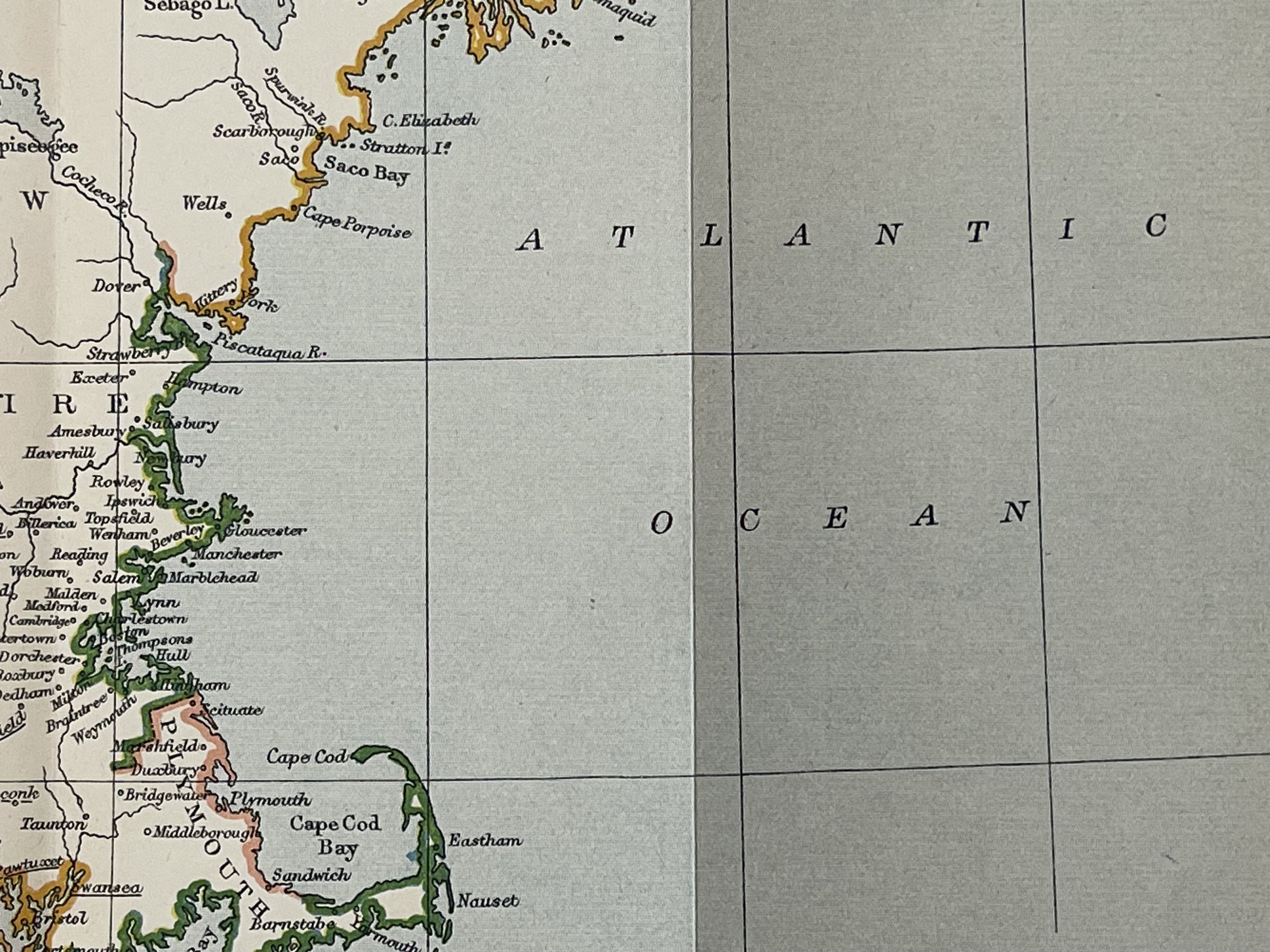
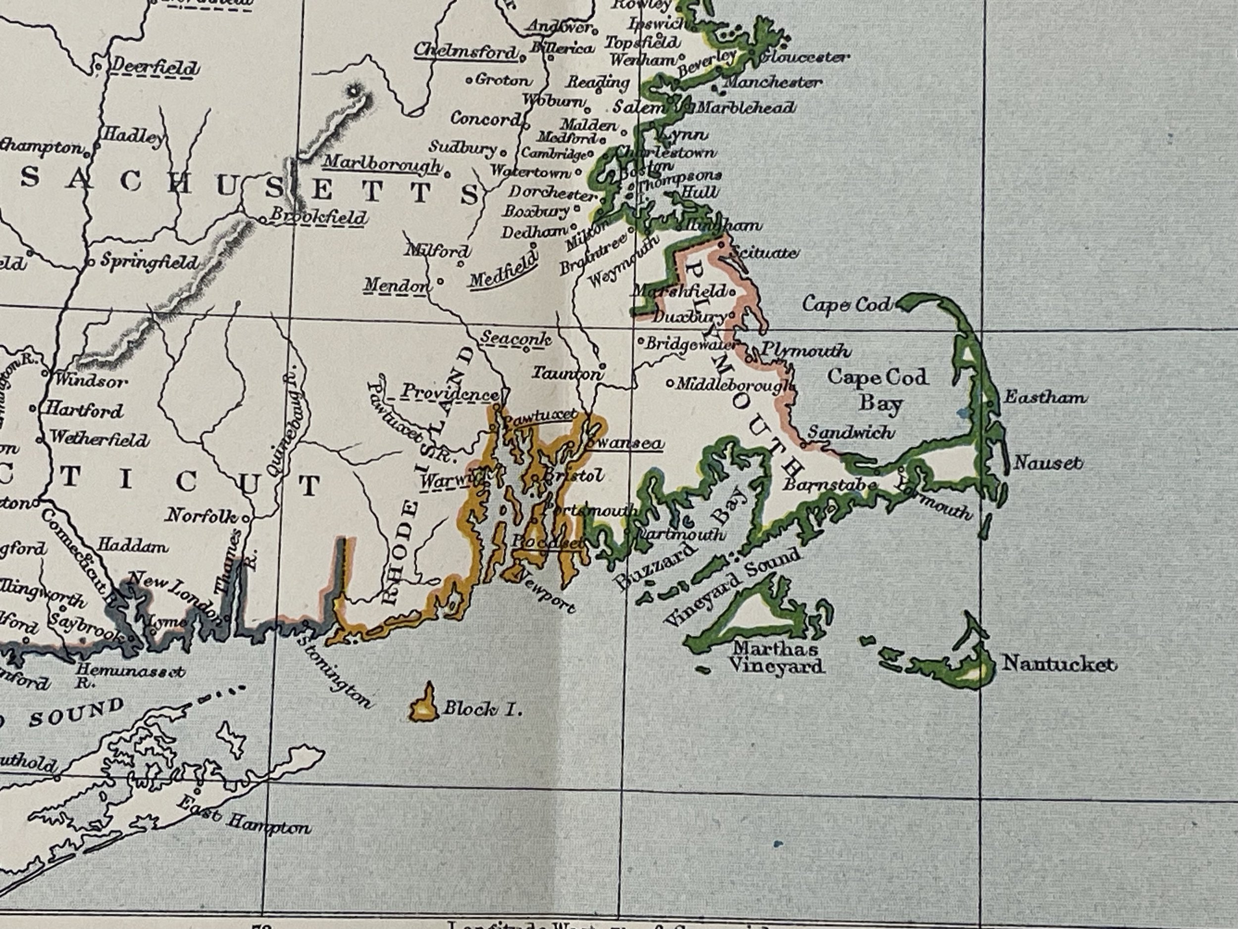
United States Civil War Map - Edward Weller - Circa 1865
Philip Henry Sheridan (1831-88) was an aggressive Union general during the American Civil War (1861-65). He demonstrated his capacity for command during assignments on the U.S. frontier and in early Civil War operations. When General Ulysses S. Grant assumed command of all Union armies in early 1864, he chose Sheridan as his new cavalry commander. Sheridan’s successful Shenandoah Valley Campaign in 1864 crushed Confederate General Jubal Early’s cavalry while destroying much of the South’s food supply. Sheridan was instrumental in General Robert E. Lee’s withdrawal from Petersburg, Virginia, after which Lee would soon surrender to Grant in April 1865 and effectively end the war.
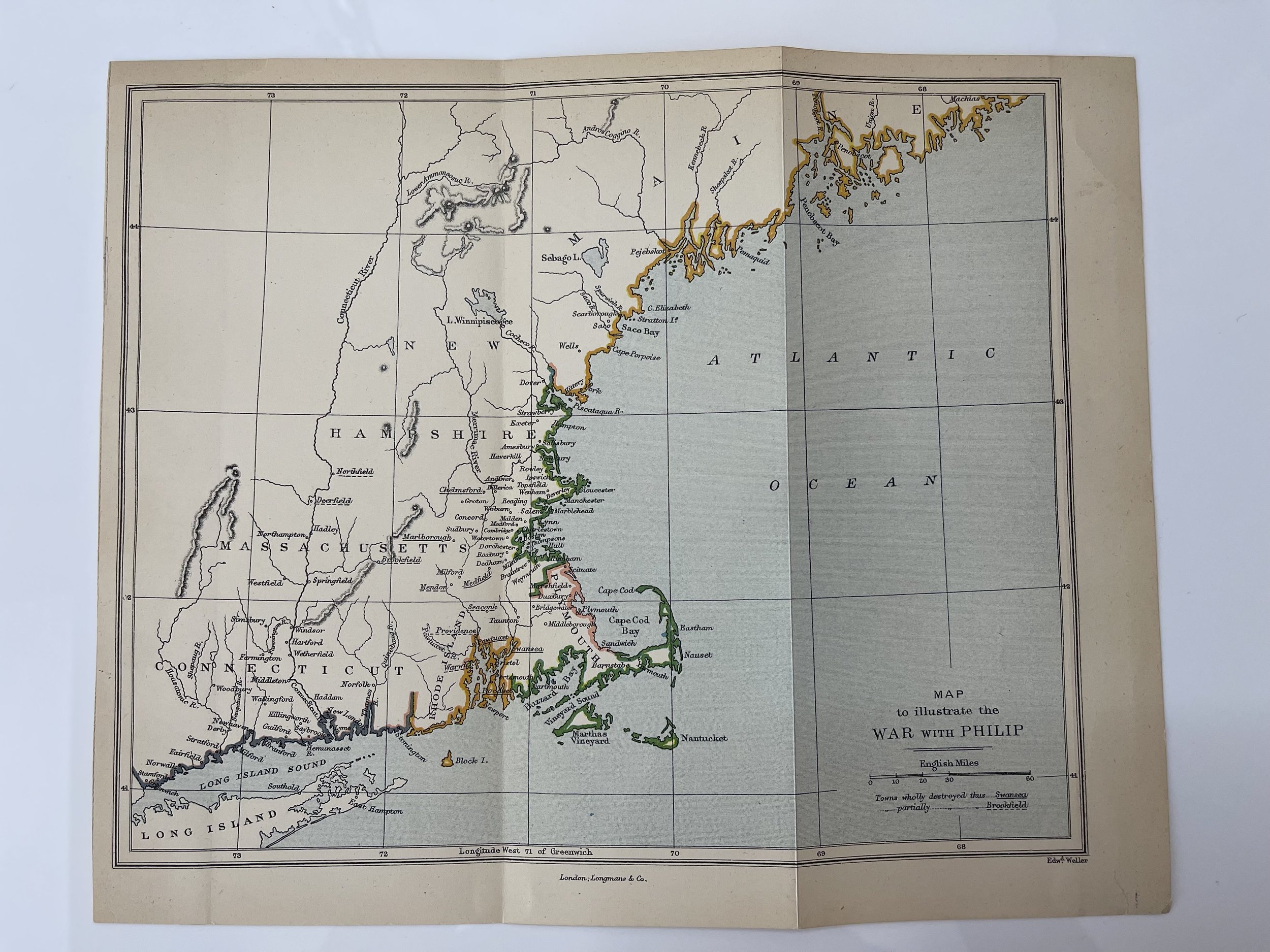
Edward Weller (1 July 1819 – May 1884) FRGS was a British engraver and cartographer who was one of the first to produce maps using lithography.
He was a "London-based engraver, cartographer and publisher, working from offices in Red Lion Square and later, Bloomsbury", who produced detailed steel plate engraved maps.
Antique atlas maps by Edward Weller (1819-1884). He is best known for his maps for Cassells "Weekly Dispatch Atlas" (c1862), including the detailed street plans of London & suburbs, and maps of Australia, Arabia, Asia including India, China & Indonesia, Canada & South Africa, plus some English county maps. He also engraved a diverse range of other maps, including for George "Philip's county atlas of England and Wales". His apprenticeship was paid for by his uncle Sidney Hall (qv). He was unofficial cartographer to the Royal Geographic Society.
Longman & Company.
Publishers of books and prints, known under a series of names reflecting successive partnerships. On the database the term Longman is used for the firm at all periods of its history.
The founder of the firm, Thomas Longman (1699-1755) was apprenticed in 1716 to John Osborn, the London bookseller, and eventually married his daughter. In1724, he took over the business of William Taylor at the Black Swan and the Ship in Paternoster Row. In 1754, he took his nephew, also Thomas Longman (1730-1797), into partnership; one of the younger Longman's sons, Thomas Norton Longman (1771-1842) succeeded to the business, in turn his sons, Thomas (1804-1879) and William (1813-1877) took over, to be followed by the former's son, Thoms Norton Longman. A succession of partners joined: 1794, Owen Rees; 1804, Hurst and Orme; 1811, Thomas Brown (1777-1869); 1824, Green. Around 1817 Longman & Co published some drawing books after Brookshaw together with John Lepard (q.v.). In 1863 the firm took over the business of John W. Parker, Son, & Bourne, and in 1890, the firm of Rivington (q.v.). Robert Guy and William L Longman became partners in 1909.
In the 1950s the firm moved from Paternoster Row to Harlow, Essex. In 1968, it was taken over by the Financial and Provincial Publishing Company, and in 1970 (under the management of Mark Longman) merged with Penguin Books, becoming the Pearson Longman Group. Extensive archives are preserved at the University of Reading.
Map in excellent condition. Pricing and grading commensurate.
Philip Henry Sheridan (1831-88) was an aggressive Union general during the American Civil War (1861-65). He demonstrated his capacity for command during assignments on the U.S. frontier and in early Civil War operations. When General Ulysses S. Grant assumed command of all Union armies in early 1864, he chose Sheridan as his new cavalry commander. Sheridan’s successful Shenandoah Valley Campaign in 1864 crushed Confederate General Jubal Early’s cavalry while destroying much of the South’s food supply. Sheridan was instrumental in General Robert E. Lee’s withdrawal from Petersburg, Virginia, after which Lee would soon surrender to Grant in April 1865 and effectively end the war.
Edward Weller (1 July 1819 – May 1884) FRGS was a British engraver and cartographer who was one of the first to produce maps using lithography.
He was a "London-based engraver, cartographer and publisher, working from offices in Red Lion Square and later, Bloomsbury", who produced detailed steel plate engraved maps.
Antique atlas maps by Edward Weller (1819-1884). He is best known for his maps for Cassells "Weekly Dispatch Atlas" (c1862), including the detailed street plans of London & suburbs, and maps of Australia, Arabia, Asia including India, China & Indonesia, Canada & South Africa, plus some English county maps. He also engraved a diverse range of other maps, including for George "Philip's county atlas of England and Wales". His apprenticeship was paid for by his uncle Sidney Hall (qv). He was unofficial cartographer to the Royal Geographic Society.
Longman & Company.
Publishers of books and prints, known under a series of names reflecting successive partnerships. On the database the term Longman is used for the firm at all periods of its history.
The founder of the firm, Thomas Longman (1699-1755) was apprenticed in 1716 to John Osborn, the London bookseller, and eventually married his daughter. In1724, he took over the business of William Taylor at the Black Swan and the Ship in Paternoster Row. In 1754, he took his nephew, also Thomas Longman (1730-1797), into partnership; one of the younger Longman's sons, Thomas Norton Longman (1771-1842) succeeded to the business, in turn his sons, Thomas (1804-1879) and William (1813-1877) took over, to be followed by the former's son, Thoms Norton Longman. A succession of partners joined: 1794, Owen Rees; 1804, Hurst and Orme; 1811, Thomas Brown (1777-1869); 1824, Green. Around 1817 Longman & Co published some drawing books after Brookshaw together with John Lepard (q.v.). In 1863 the firm took over the business of John W. Parker, Son, & Bourne, and in 1890, the firm of Rivington (q.v.). Robert Guy and William L Longman became partners in 1909.
In the 1950s the firm moved from Paternoster Row to Harlow, Essex. In 1968, it was taken over by the Financial and Provincial Publishing Company, and in 1970 (under the management of Mark Longman) merged with Penguin Books, becoming the Pearson Longman Group. Extensive archives are preserved at the University of Reading.
Map in excellent condition. Pricing and grading commensurate.
Code : A1054
Cartographer : Cartographer / Engraver / Publisher: Edward Weller
Date : Publication Place / Date - 1865
Size : Sheet size: 26.5 x 22 Cm
Availability : Available
Type - Genuine - Antique
Grading A
Where Applicable - Folds as issued. Light box photo shows the folio leaf centre margin hinge ‘glue’, this is not visible otherwise.
Tracked postage, in casement. Please contact me for postal quotation outside of the UK.